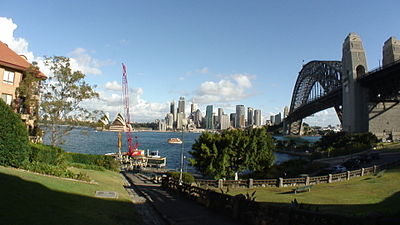
Jeffrey Street
The national Australian television station uses Jeffrey Street on an almost daily basis as their camera location or backdrop for the evening news bulletins.
Lightfoot subsequently returned to Australia on HMS Calcutta as a free settler, participating in the effort to establish a settlement at Port Phillip, near the modern city of Melbourne.
Thomas Muir of Huntershill, a Scots Martyr accused of religious subversion, acquired Lightfoot's grant in 1794, the same year in which he arrived in the colony.
[10] However, it is likely that Muir, who had studied law at Edinburgh University and had passed his bar examinations in 1787 at the age of 22, had arranged a private contract for the sale of the land.
He laboured, with his own hands, to improve and cultivate the land he had purchased, and which, till then, was in a state of native wildness; and, in remembrance of his patrimonial tide and estate in Scotland, he called it Huntershill, by which name we hope it is still known.
A good account of his escape from the colony appears in several books and Pierre François Péron chronicled Otter's voyage across the Pacific.
[32] In January 1792 Robert Ryan received a discharge from the New South Wales Marine Corps and a land grant of 60 acres (240,000 m2) located at Mount Pitt Valley, Queenborough Norfolk Island.
After some unprofitable commercial experience in Greenock, Robert at 27 went to India to join his elder brother John, a partner in the Calcutta agency house of Campbell Clarke & Co., established in 1790.
[37] In January 1805, Campbell returned to England and was involved in a famous court case in London which precipitated the breaking of the monopoly of the British East India Company.
Before leaving for England Campbell had approached Philip Gidley King with a plan for to construct a ship in Sydney of 136-tons burthen, and had identified the site of the proposed shipyard in Kirribilli.
[43] Some sources incorrectly state that North Head was the first site in Australia to be used for quarantine purposes when the Bussorah Merchant was detained in Spring Cove, Sydney, in 1828.
Twenty-three-year-old James Milson arrived in Port Jackson (Sydney) on the Albion on 19 August 1806[50] as one of the earliest free settlers in the Colony of New South Wales.
[51] Milson did well in the Colony of New South Wales, and established a number of prosperous businesses, including an orchard and a dairy in the vicinity of Jeffrey Street.
His name was mentioned frequently in the papers at the time in a professional capacity, including shipping news, customs lists and police events.
Greencliffe was one of North Sydney's former early sandstone homes, and occupied a prime position at Kirribilli possessing outstanding views of the harbour.
[77][78][79] In 1843, at the end of a severe five-year-long drought, Jeffreys purchased a property of 1,742 acres (7.05 km2), near Queanbeyan, NSW, which he named "Acton" after a town in Denbighshire, Wales.
Robert Campbell was one of the considerable pastoralists, merchants and land-owners in the early colony of NSW with significant land holdings in Kirribilli, Duntroon on the Limestone Plains, and the Canterbury Estate near Sydney, among others.
[77] He was the Elective Member of the first Legislative Council 1843 - 1856 for the Pastoral District of Maneroo [77] Jeffreys died in England 1861 and his family also returned there to live.
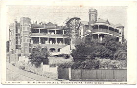
[82] Plans and a photograph (circa 1907) remain of the early cottage at the corner of Pitt and Jeffrey Street, the site of what is now St Aloysius' College.
In 1903 "Star of the Sea" became the chapel for St Aloysius' College, which had just moved from Surry Hills into a large house next to the church formerly owned by Dr.
The heritage listing notes that it is a large two storey Italianate house with an asymmetrical front having a projecting three-facet bay with moulded details to segmental arch windows.
[121] The present day site of St Aloysius' College was previously occupied by a small, stone church built in 1863 by Congregationalists, Wesleyans and Anglicans.
Archbishop of Sydney Cardinal Moran urged the Jesuits to move St Aloysius' College from Bourke Street to a site in Kirribilli near the church in order to give regular service to the Catholics of the area.
There are carved bargeboards, finials and a lancet ventillator to the gable ends, three-light square-headed windows and iron lace, columns and balustrades to the verandahs."
"[2][127] At its meeting of 8 March 2010, North Sydney Council's Planning and Development Committee resolved to investigate the establishment of a new heritage conservation area centred on Jeffreys Street, Kirribilli.A consultant was engaged to prepare a report.
[128] A report was subsequently completed by John Oultram Heritage & Design titled Proposed Conservation Area, Jeffreys Street, Kirribilli.
[133] The North Sydney Council website is internally inconsistent: It is widely agreed that the signs on the wharf that read "Jeffereys" Street are a mistake.
Objections raised included concerns related to the party wall, consent, noise, privacy, reduction in heritage integrity, light, and detrimental impact on the strong geometric shapes of the gable roofs on the terraces and their stepping down the hill.
[140] Jeffrey Street was mentioned in the 2005 case of Meehan v. North Sydney Council which related to a nearby property at 40 Kirribilli Avenue.
This led to the resolution of a long-running dispute between the owners in the strata scheme which had involved 10 applications to the CTTT and a reported 100 to North Sydney Council.