Jupitagon River
[4] Père Arthur Gallant (1896-1976) was a Eudist missionary at Rivière-Saint-Jean with responsibility for the dessertes of Longue-Pointe-de-Mingan, Magpie and Jupitagon from 1928 to 1938.
[1] On the 1744 map by Charlevoix, published by Jacques-Nicolas Bellin in the Histoire générale de la Nouvelle-France (General History of New France), the Jupitagon River is referred to as Ouapitougan.
[3] A small part of the northern watershed is on the plateau of the Canadian Shield, where the land slopes steeply and reaches an elevation of 420 metres (1,380 ft).
The coastal plain is 8 kilometres (5.0 mi) wide, relatively flat land that slopes from 150 metres (490 ft) down to the shore of the Gulf of Saint Lawrence.
The bedrock of the plateau and the piedmont area is covered by an undifferentiated and discontinuous layer of glacial till no more than 2 metres (6 ft 7 in).
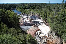
[7] It is generally narrow and shallow, apart from a few places such as Lake Atsuk about 15 kilometres (9.3 mi) upstream and the base of the falls at its mouth.
The river has two sizable tributaries, the Petite rivière au Foin in the southeast part and an unnamed stream in the southwest.
Inland in the piedmont and plateau area the forest is a mix of black spruce and balsam fir (Abies balsamea), with mossy groundcover.
There was a serious infestation of hemlock looper moths (Lambdina fiscellaria) in the late 1990s and early 2000s which caused widespread defoliation of the fir trees.
[11] Other species are brook trout (Salvelinus fontinalis), American eel (Anguilla rostrata), rainbow smelt (Osmerus mordax) and three-spined stickleback (Gasterosteus aculeatus).
In view of the rapidly declining Atlantic salmon population catch-and-release should have been implemented on all rivers apart from northern Quebec.