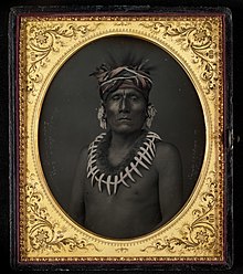
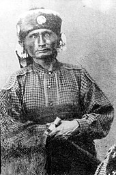
Kaw people
The name of Topeka, capital city of Kansas, is said to be the Kaw word Tó Ppí Kˀé meaning "a good place to grow potatoes".
Oral history indicates that the ancestors of the five Dhegiha tribes migrated west from the east, possibly somewhere around the Ohio Valley.
The Quapaw separated from the other Dhegiha at the mouth of the Ohio, going down the Mississippi River to live in what is today the state of Arkansas.
The reason for leaving the traditional home may have been due to the mass displacement westward of Indian tribes caused by European settlement on the Atlantic Coast of the United States.
He found them living in a single large village near the future site of the town of Doniphan, Kansas.
By the late 1700s, the Kanza took up residence on the Kansas River,[10] but the ruins of their earlier villages and Fort Cavagnial were a landmark for travelers in the early 1800s.
This new settlement was distanced from the sometimes antagonistic relations with tribes from east of the Missouri River, but was closer to the Pawnee, with whom they were often in conflict.
They were increasingly hemmed in, first, by Eastern Indians forced to migrate west and, secondly, by White settlers who coveted the "beautiful aspects" and "rich and exuberant soils" of Kaw lands.
In 1825, the Kaw ceded a huge area of land in Missouri and Kansas to the United States in exchange for a promise of an annuity of $3,500 annually for twenty years.
The promised annuity—to be paid in goods and services—was often late in arriving or found its way into the pockets of unscrupulous government officials and merchants.
[16] Council Grove is a beautiful area of forests, water, and tall grass prairie, but it was probably the worst location that could have been selected for the already weakened and demoralized tribe.
It was a favorite stopping place for the rough-hewn teamsters and traders and voracious merchants on the Santa Fe Trail.
They served in Indian Territory (Oklahoma) and Arkansas during the war and 21 of them never came home—a large loss to the already diminished numbers of the tribe.
The two Indian armies put on a military pageant featuring horsemanship, fearsome howls and curses, and volleys of bullets and arrows.
After four hours, the Cheyenne retired with a few stolen horses and a peace offering of coffee and sugar by the Council Grove merchants.
During the battle, the mixed-blood Kaw interpreter, Joseph James, Jr. (more commonly known as Jojim or Joe Jim) galloped 60 miles to Topeka to request assistance from the Governor.
Two weeks later, 533 men, women, and children arrived at the junction of the Arkansas River and Beaver Creek in what would become Kay County, Oklahoma.
[21] The Kaw made their last successful buffalo hunt that winter, journeying on horseback to the Great Salt Plains.
In 1884, to manage grazing leases, they elected a government with a Chief Councilor and a representative from each of the four Kaw bands: the Picayune, Koholo, Rock Creek, and Half-breed.
[23] The Kaws found security from white harassment on their Indian Territory lands, but the tribe continued to decline, especially the full bloods.