Killwangen
Of the rest of the land, 19.3% is settled (buildings or roads) and the remainder (2.5%) is non-productive (rivers or lakes).
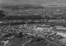
Killwangen lies on the south side of the Limmat river, within easy walking distance of the Heitersberg.
Neighboring towns are Wurenlos to the North, Spreitenbach to the east, Neuenhof to the West and Oberrohrdorf to the south.
The blazon of the municipal coat of arms is Gules a Mullet Argent under a Chevron rose of the same.
[10] The historical population is given in the following table:[3][8] Members of the town council are voted on once every four years.
The five town councilors for 2014-2017 are as follows: From the 2000 census[update], 667 or 48.4% are Roman Catholic, while 414 or 30.1% belonged to the Swiss Reformed Church.
[9] Killwangen is primarily a bedroom community, as most of the employed workforce commutes daily to Baden, Spreitenbach or to jobs in the Zurich agglomeration.
Children from the 7th class and older travel to nearby Spreitenbach to middle school.
High schools in Wettingen and Baden follow for those students with qualifying performance.