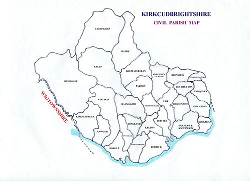
Kirkcudbrightshire
Kirkcudbrightshire forms the eastern part of the medieval lordship of Galloway, which retained a degree of autonomy until it was fully absorbed by Scotland in the 13th century.
[1] It is bounded on the north by Ayrshire, on the west by Wigtownshire, on the south by the Irish Sea and Solway Firth, and on the east by Dumfriesshire.
The country west of the Nith was originally peopled by a tribe of Celts called Novantae, who long retained their independence.
[2] After Malcolm Canmore defeated and killed Macbeth in 1057, he married the dead king's relative, Ingibiorg, a Pictish princess, (the view that there were Picts in Galloway in historical times cannot be wholly rejected) an event which marked the beginning of the decay of Norse influence.
Following the death of Lord Alan of Galloway in 1234 the area was brought fully under the control of the Scottish crown.
[2] In 1369 Archibald the Grim, Earl of Douglas, was given the part of Galloway east of the River Cree, where he appointed a steward to administer the area, which became known as the Stewartry of Kirkcudbright.
The following year, he acquired the rest of Galloway west of the Cree, which continued to be administered by the king's sheriff, and so became known as the Shire of Wigtown.
This led to the local custom of referring to Kirkcudbrightshire as "The Stewartry" and Wigtownshire as "The Shire", which continued into the 20th century.
After the Battle of Solway Moss (1542) the shires of Kirkcudbright and Dumfries fell under English rule for a short period.
After the union (1707) things mended slowly but surely, curious evidence of growing commercial prosperity being the enormous extent to which smuggling was carried on.
No coast could serve the "free traders" better than the shores of Kirkcudbright, and the contraband trade flourished until the 19th century.
[12] In the 1760s a military road was constructed from Bridge of Sark,[13] near Gretna, Dumfries and Galloway to Portpatrick by Major William Caulfeild.
[19] Silurian and Ordovician rocks are the most important in this county; they are thrown into oft-repeated folds with their axes lying in a north-east–south-west direction.
They occupy all the northern part of the county north-west of a line which runs some 3 m. north of New Galloway and just south of the Rinns of Kells.
South-east of this line graptolitic Silurian shales of Llandovery age prevail; they are found around Dalry, Creetown, New Galloway, Castle Douglas and Kirkcudbright.
They are best developed about Kirkbean, where they include a basal red breccia followed by conglomerates, grits and cement stones of Calciferous Sandstone age.