Kola Tembien
[3][4][5] Notable landmarks in this woreda include the monastery of Abba Yohanni and the monolithic church of Gebriel Wukien, both of which are north of Abiy Addi.
The ceiling is carved, and on either side are two elongated chambers which could have been the beginnings of an ambulatory, or else were living quarters.
The main entrance to the church is at a lower level, down a number of steps and immediately on entering, a rectangular pool of water fed by a spring to the right.
The entrance to the church buildings is in reality part of the rock forming two enclosures or courtyards, both hewn and open to the air.
The church ceiling is the same height throughout, with capitals, arches and cupolas to each bay, with a hewn tabot in the apse.
The plan is sophisticated, with a central axis running north-south and the two open courtyards cut deep into the rock.
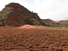
[6] High in the mountains northwest of Abiy Addi, the Geramba rock church (13°38.84′N 39°1.55′E / 13.64733°N 39.02583°E / 13.64733; 39.02583) is hewn in the top of a butte of Tertiary silicified limestone, under a thin cover of basalt.
The columns are rather crudely carved, although slightly cruciform in plan and with bracket capitals much modified before the springing of the rough arches.
A sample enumeration performed by the CSA in 2001 interviewed 27,665 farmers in this woreda, who held an average of 0.81 hectares of land.
Of the 22,402 hectares of private land surveyed, 85.28% was in cultivation, 0.87% pasture, 10.78% fallow, 0.23% woodland, and 2.84% was devoted to other uses.
[8][9] Part of the water that could be used for irrigation is lost through seepage; the positive side-effect is that this contributes to groundwater recharge.