La Guajira Department
It occupies most of the Guajira Peninsula in the northeast region of the country, on the Caribbean Sea and bordering Venezuela, at the northernmost tip of South America.
During the colonial era, the territory of La Guajira was disputed by the governors of Santa Marta and Venezuela, owing to deposits of pearls.
In the 1930s, numerous immigrants came to the area from the Middle East (Christian Arabs, Maronites in particular, and Shi'i Muslims) from Lebanon, Syria, Palestine and Jordan.
A popular ecotourist destination is Cabo de la Vela, a small fishing village located on the headland of the peninsula in the Guajira desert.
[7][8] The northern part of the department consists of arid plains called the Guajira-Barranquilla xeric scrub, whose dryness is caused by the rain shadow of the Sierra Nevada de Santa Marta.
[9] The Ranchería River, which also rises in the Sierra Nevada de Santa Marta, crosses the Guajira Peninsula from south to north and flows through the Valley of Upar and into the Caribbean Sea.
The mountain range is an isolated ecosystem in the middle of the La Guajira Desert, near the Caribbean Sea, between the villages of Nazareth, Ichipa and Tawara.
[10] The Sierra Nevada de Santa Marta mountain range is located on the Caribbean Sea and is shared with the departments of Magdalena and Cesar.
[11] The Cerro Pintao ("Painted Hill")—on the slopes of which sit the municipalities of San Juan del Cesar, El Molino, Villanueva, and Urumita and, in the Department of Cesar, the municipalities of Manaure, La Paz, San Diego, and Codazzi—covers an area of 25,000 hectares (62,000 acres), with altitudes ranging from 1,600 to 3,688 metres (5,249 to 12,100 ft), forming a Páramo ecosystem, and gives birth to some 13 rivers of Colombia.
[12] The Santuario de Flora y Fauna los Flamencos (Flamingos Fauna and Flora Sanctuary) is located on the coastline of the municipality of Riohacha, between the village of Camarones and the Tapias River, and covers 7,000 hectares (17,000 acres) The sanctuary has four lagoons (Manzanillo, Navío Quebrado, Tocoromanes, and Laguna Grande) and numerous streams which serve as habitat for the flamingos and numerous other endemic species.
[13] Located in the village of Musichi, the Flamingos Protection Area is within the municipality of Manaure and contains numerous lagoons that are used by locals for the artisanal making of salt.
[14] During the pre-Columbian era, present-day La Guajira was inhabited predominantly by indigenous tribes belonging, in the dry northern lowlands, mostly to the Wayuu (Guajiros, Macuiros, Anates, Caquetios, Wayunaiki, Cuanaos, Onotos and Eneales) and Cocina people, and, in the south, to the Kogui, Arhuaco, Guanebucan, and Chimila ethnic groups, among others.
[16] Archaeological digs have uncovered the sites of fishing communities that used pottery on the central eastern side of the Guajira Peninsula, dating to the 10th century BC.
[16] In 1498, the Guajira Peninsula was first seen by Spanish explorers led by Alonso de Ojeda, who sailed the coast, but didn't land.
In 1544, due to constant attacks from the indigenous, and from Spanish from the neighboring Captaincy of Venezuela who were after the large deposits of pearls, the village was moved to present-day Riohacha and refounded by Nikolaus Federmann.
[23] La Guajira was one of the territories in Colombia that endured a period of isolation during the Spanish colonization of the Americas, due to the resistance of the indigenous peoples, predominantly the Wayuu.
In 1718, Governor Soto de Herrera called the Wayuu, "barbarians, horse thieves, worthy of death, without God, without law and without a king".
On May 2, 1769, at El Rincón, near Río de la Hacha, they set the village afire, burning the church and two Spaniards who had taken refuge in it, and capturing the priest.
In 1905, Pope Pius X created the Vicariate of La Guajira and, as the first vicar, Friar Atanasio Vicente Soler y Royo attempted to "civilize" the Wayuu people.
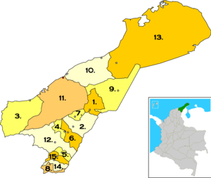
The Department of La Guajira is formed into 15 municipalities, each administered by a popularly elected mayor and a city council, as well as municipal-level courts.
12 of the municipalities are part of a government program called "Special Units for Frontier and Department Frontier Zone": San Juan del Cesar, La Jagua del Pilar, Barrancas, El Molino, Fonseca, Hatonuevo, Maicao, Uribia, Urumita, Villanueva, Manaure, and Riohacha.
The Department of La Guajira is also composed of 126 corregimientos (local magistracies), 49 inspecciones de policía (police districts) and 10 caseríos (villages), distributed throughout the municipalities.
[30] According to the DANE (Colombian statistics bureau) 2005 Census, 44.9% of the population of the Department of La Guajira was indigenous, mostly belonging to the Arhuaco, Koguis, Wiwa, and Wayuu tribes.
7.5% was of Afro-Colombian descent; while the remaining 47.6% of the population did not consider itself part of a particular ethnic group, except for Middle Eastern descendants, who have migrated here throughout the 20th century.
The institution offers technical as well as undergraduate and graduate programs in natural sciences, engineering, economics, education, administration, and the humanities.
[34] The service industry follows, including electricity, gas, potable water, transport and communications, accounting for 11.06% of the total revenue.
[34] The Department of La Guajira in 2005 produced mainly tobacco, coffee, yuca, plantain, coconuts, ñame, arracacha, oil palm, and sugar cane.
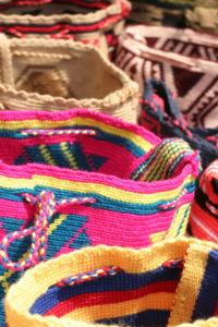
Literature in La Guajira has been both written in Spanish and Wayuunaiki, most of it describing the myths, the sacred, the tragic, the epics, the legends, heroism, the magic, the comedy, and romanticism autochthonous to the region and directly influenced by the Costumbrismo, including physiology and sexuality.
The accordions and guitars first used for vallenato music were allegedly acquired in La Guajira as contraband arriving from the nearby island of Aruba, in the Caribbean Sea.
[42][43][44] Amazonas Antioquia Arauca Atlántico Bolívar Boyacá Caldas Caquetá Casanare Cauca Cesar Chocó Córdoba Cundinamarca Guainía Guaviare Huila La Guajira Magdalena Meta Nariño N. Santander Putumayo Quindío Risaralda San Andrés Santander Sucre Tolima Valle del Cauca Vaupés Vichada