Lakes on Mars
[1][2][3] However, over the decades, as more parts of the planet were imaged with better cameras on more sophisticated satellites, Mars showed evidence of past river valleys, lakes and present ice in glaciers and in the ground.
[5][6][7] Also, some researchers maintain that surface liquid water could have existed for periods of time due to geothermal effects, chemical composition, or asteroid impacts.
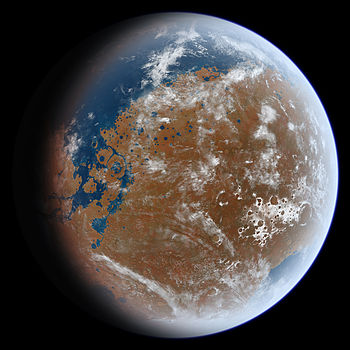
Such an arrangement is visible around places on Mars that are supposed to have contained large bodies of water, including around a possible ocean in the north.
[40][41][42] In February 2019, a group of European scientists published geological evidence of an ancient planet-wide groundwater system that was probably connected to a Martian ocean.
[45] Some of the craters studied were Pettit, Sagan, Nicholson, Mclaughlin, du Martheray, Tombaugh, Mojave, Curie, Oyama, and Wahoo.
[52][53][54] However, for such an ocean to have existed, early Mars would have required a magnetosphere, a denser atmosphere, and warmer climate to allow liquid water to remain at the surface.
[55] Features first shown by the Viking orbiters in 1976 revealed two possible ancient shorelines near the pole, Arabia and Deuteronilus, each thousands of kilometers long.
Networks of gullies that merge into larger channels imply erosion by a liquid flow and resemble ancient riverbeds on Earth.
Enormous channels, 25 km wide and several hundred meters deep, appear to have flowed directly from underground aquifers in the Southern uplands into the Northern plains.
Beginning in 1998, scientists Michael Malin and Kenneth Edgett set out to investigate, using cameras on board the Mars Global Surveyor with a resolution five to ten times better than those of the Viking orbiter, in places that would test shorelines proposed by others in the scientific literature.
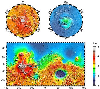
[64] Research published in 2012 using data from MARSIS, a radar on board the Mars Express orbiter, supports the hypothesis of a former large northern ocean.
The European Space Agency's Mars Express found possible evidence for the sulfates epsomite and kieserite, minerals that form in water.
Melas Chasma is thought to have once contained a lake, as it is the deepest part of the Valles Marineris system at 11 km (7 miles) below the surrounding surface.
[79] Moreover, in a 2015 study of southwestern Melas Chasma, using high-resolution image, topographic and spectral datasets, eleven fan-shaped landforms were found.
The basin is located in the southern highlands of Mars and is thought to have been formed about 3.9 billion years ago, during the Late Heavy Bombardment.
In addition, Mars orbiting laser altimeter (MOLA) data show that the contacts of these sedimentary units mark contours of constant elevation for thousands of km, and in one case all around the basin.
[93][94][95][96] Dao Vallis begins near a large volcano, called Hadriaca Patera, so it is thought to have received water when hot magma melted huge amounts of ice in the frozen ground.
[97] The partially circular depressions on the left side of the channel in the adjacent image suggest that groundwater sapping also contributed water.
[104][105][106][107][108][109][110] On 5 August 2012, the Mars Science Laboratory rover, Curiosity, landed at the foot of a layered mountain inside Gale crater.
On 27 September 2012, scientists announced that the Curiosity found evidence for an ancient streambed suggesting a "vigorous flow" of water on Mars.
[111][112][113] On 9 December 2013, NASA reported that Gale Crater contained an ancient freshwater lake which could have been a hospitable environment for microbial life.
This liquid water environment possessed a neutral pH, low salinity, and iron and sulfur in forms usable to certain types of microorganisms.
[116] Clay minerals (trioctahedral) that are formed in the presence of water were found by Curiosity in sedimentary rocks (mudstones) at Yellowknife Bay in Gale Crater.
The history of water at Gale, as recorded in its rocks, is giving Curiosity many clues to study as it pieces together whether Mars ever could have been a habitat for microbes.
[155][156][157] The western Elysium Planitia basin can be described as almost a perfect equipotential surface because it slopes only about 10 m over a 500 km distance—that’s about as level as the Earth’s ocean.
[165][166] An article written by 22 researchers in Icarus concluded that the impact that formed the Argyre basin probably struck an ice cap or a thick permafrost layer.
This region shows a great deal of evidence of glacial activity with flow features, crevasse-like fractures, drumlins, eskers, tarns, aretes, cirques, horns, U-shaped valleys, and terraces.
[125][211] Research with an orbiting near-infrared spectrometer, which reveals the types of minerals present based on the wavelengths of light they absorb, found evidence of layers of both clay and sulfates in Columbus crater.
[215] The CRISM instrument on the Mars Reconnaissance Orbiter found kaolinite, hydrated sulfates including alunite and possibly jarosite.
[79] Further study concluded that gypsum, polyhydrated and monohydrated Mg/Fe-sulfates were common and small deposits of montmorillonite, Fe/Mg-phyllosilicates, and crystalline ferric oxide or hydroxide were found.