Lenape
During the last decades of the 18th century, European settlers and the effects of the American Revolutionary War displaced most Lenape from their homelands[12] and pushed them north and west.
In 2002, the Delaware Tribe of Indians received grant money to fund The Lenape Talking Dictionary, preserving and digitizing the Southern Unami dialect.
[22] At the time of European settlement in North America, a Lenape would have identified primarily with their immediate family and clan, friends, and village unit and, after that, with surrounding and familiar village units followed by more distant neighbors who spoke the same dialect, and finally, with those in the surrounding area who spoke mutually comprehensible languages, including the Nanticoke people who lived to their south and west in present western Delaware and eastern Maryland.
[28] Within a marriage itself, men and women had relatively separate and equal rights, each controlling their own property and debts, showing further signs of a woman's power in the hierarchical structure.
[41] The success of these methods allowed the tribe to maintain a larger population than other, nomadic hunter-gatherer peoples in North America at the time, could support.
European settlers and traders from the 17th-century colonies of New Netherland and New Sweden traded with the Lenape for agricultural products, mainly maize, in exchange for iron tools.
In hot weather men and women wore only loin cloth and skirt respectively, while they used beaver pelts or bear skins to serve as winter mantles.
The explorer Giovanni da Verrazzano was greeted by local Lenape who came by canoe, after his ship entered what is now called Lower New York Bay.
[52] Although never politically unified, the confederation of the Lenape roughly encompassed the area around and between the Delaware and lower Hudson rivers, and included the western part of Long Island in present-day New York.
[53] Some of their place names, such as Manhattan ("the island of many hills"[54]), Raritan, and Tappan were adopted by Dutch and English colonists to identify the Lenape people that lived there.
[58] The Lenape's quick adoption of trade goods, and their desire to trap furs to meet high European demand, resulted in over-harvesting the beaver population in the lower Hudson Valley.
[59] During the resulting Beaver Wars in the first half of the 17th century, European colonists were careful to keep firearms from the coastally located Lenape,[11] while rival Iroquoian peoples in the north and west such as the Susquehannocks and Confederation of the Iroquois became comparatively well-armed.
[62] Epidemics of newly introduced European infectious diseases, such as smallpox, measles, cholera, influenza, and dysentery,[63] reduced the populations of Lenape.
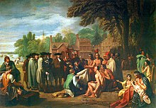
According to historian Steven C. Harper, what followed was a "convoluted sequence of deception, fraud, and extortion orchestrated by the Pennsylvania government that is commonly known as the Walking Purchase".
[66] Led by Reverend John Brainerd, colonists forcefully relocated 200 people to Indian Mills, then known as Brotherton, an industrial town with gristills and sawmills,[67] that was the first Native American reservation in New Jersey.
[69] Through the 18th century, many Lenape moved west into the relatively depopulated upper Ohio River basin, but they also sporadically launched violent raids on settlers far outside the area.
His son Captain Bull responded by attacking settlers, sponsored by the Susquehanna Company, in the present-day Wyoming Valley region of Pennsylvania.
They believed that by the Royal Proclamation of 1763, restricting Anglo-American settlement to east of the Appalachian Mountains, the British would help them preserve a Native American territory.
In return, Killbuck requested that the Americans build a fort near the major Lenape village of Coshocton, to provide them with protection from potential attacks by British-allied Indians and Loyalists.
The Lenape had lost their protectors and found themselves without solid allies in the conflict, which compounded their dispossession at the hand of encroaching American pioneers during and after the war.
In return, the U.S. relinquished its claims to "all other Indian lands northward of the river Ohio, eastward of the Mississippi, and westward and southward of the Great Lakes and the waters uniting them".
[68] In the early 19th century the amateur anthropologist Silas Wood published a book claiming that there were several American Indian tribes that were distinct to Long Island, New York.
Modern scientific scholarship has shown that in fact two linguistic groups representing two distinct Algonquian cultural identities lived on the island, not "13 individual tribes" as asserted by Wood.
In 1822, the Munsee Lenape of Washington Valley who had moved to Stockbridge were forcefully displaced by white colonists again, over 900 miles' travel away,[88] to Green Bay, Wisconsin.
[90] Many Lenape participated in the exploration of the western United States, working as trappers with the mountain men, and as guides and hunters for wagon trains.
The Lenape requested Mier y Terán to issue them land grants and send teachers, so they might learn to read and write the Spanish language.
Lenape scouts and their families were allowed to settle along the Brazos and Bosque rivers in order to influence the Comanche to come to the Texas government for a peace conference.
In 1848, John Conner (Lenape) guided the Chihuahua-El Paso Expedition and was granted a league of land by a special act of the Texas legislature in 1853.
Major B.F. Robinson, the Indian Agent appointed in 1855, did his best, but could not control the hundreds of white trespassers who stole stock, cut timber, and built houses and squatted on Lenape lands.
In its conclusion the court stated: "... we find that the Delaware Nation's aboriginal rights to Tatamy's Place were extinguished in 1737 and that, later, fee title to the land was granted to Chief Tatamy—not to the tribe as a collectivity.