2005 levee failures in Greater New Orleans
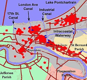
On Monday, August 29, 2005, there were over 50 failures of the levees and flood walls protecting New Orleans, Louisiana, and its suburbs following passage of Hurricane Katrina.
[1] When Katrina's storm surge arrived, the hurricane protection system, authorized by Congress forty years earlier, was between 60–90% complete.
Six major investigations were conducted by civil engineers and other experts in an attempt to identify the underlying reasons for the failure of the federal flood protection system.
"[6] The same NHC report also revised the total damage estimate keeping Hurricane Katrina as the costliest storm ever––$190 billion according to NOAA's National Centers for Environmental Information.
[9] Closure of the waterways resulted in a drastic lowering of the water table by the city's drainage system, causing some areas to settle by up to 8 feet (2 m) due to the compacting and desiccation of the underlying organic soils.
Others collapsed after a brief period of overtopping (southeast breach of the Industrial Canal) caused scouring or erosion of the earthen levee walls.
On the west edge of New Orleans, between 6 and 7:00 am, a monolith on the east side of the London Avenue Canal failed and allowed water over 10 feet deep into Fillmore Gardens, a mostly Black middle class neighborhood.
The primary mechanism of failure for levees protecting eastern New Orleans was the existence of sand in 10% of places instead of thick Louisiana clay.
The primary mechanism of failure for the levees protecting St. Bernard Parish was overtopping due to negligent maintenance[26] of the Mississippi River Gulf Outlet, a navigation channel, built and maintained by the Corps of Engineers.
"The engineers made an unconservative (i.e., erring toward unsafe) interpretation of the data: the soil below the levee was actually weaker than that used in the I-wall design" (ASCE: External Review Panel, pg 48).
According to Robert Bea, a geotechnical engineer from the University of California, Berkeley, the weak soil made the floodwall very vulnerable to the stresses of a large flood.
As Katrina's storm surge filled the canal, water pressure rose in the soil underneath the wall and in the peat layer.
When the rising pressure and moving water overcame the soil's strength, it suddenly shifted, taking surrounding material – and the wall – with it.
[30] IPET consisted of independent and recognized experts from the Universities of Maryland, Florida, Notre Dame, and Virginia Polytechnic Institute, the National Oceanic and Atmospheric Administration, the South Florida Water Management District, Harris County Flood Control District (Houston, TX), the United States Department of Agriculture, and the United States Bureau of Reclamation as well as those from USACE.
IPET's final findings indicated that, With the exception of four foundation design failures, all of the major breaches were caused by overtopping and subsequent erosion.
The levee-floodwall designs for the 17th Street and London Avenue Outfall Canals and the northeast breach of the IHNC were inadequate due to steel sheet-pilings driven to depths that were too shallow.
The credibility of the IPET was also challenged in a 42-page letter to the American Society of Civil Engineers (ASCE) submitted by Dr. Ray M. Seed, co-chair of the ILIT study.
Seed described an early intentional plan by the Corps of Engineers to hide their mistakes in the New Orleans flooding after Katrina and to intimidate anyone who tried to intervene.
[33] Investigators focused on the 17th Street and London Avenue canals, where evidence showed they were breached even though water did not flow over their tops, indicating a design or construction flaw.
Eyewitness accounts and other evidence show that levees and flood walls in other parts of the city, such as along the Industrial Canal, were topped by floodwaters first, then breached or eroded.
"[37] Dr. Robert Bea, chair of an independent levee investigation team, has said that the New Orleans–based design firm Modjeski and Masters could have followed correct procedures in calculating safety factors for the flood walls.
That decision saved approximately US$100 million, but significantly reduced overall engineering reliability..."[40] According to Professor Raymond Seed of the University of California, Berkeley, a surge of water estimated at 24 feet (7 m), about 10 feet (3 m) higher than the height of the levees along the city's eastern flank, swept into New Orleans from the Gulf of Mexico, causing most of the flooding in the city.
On October 19, 2005, Defense Secretary Donald Rumsfeld announced that an independent panel of experts, under the direction of the National Academy of Sciences, would convene to evaluate the performance of the New Orleans levee system, and issue a final report in eight months.
[46] The report cited the Flood Control Act of 1965 legislation which was enacted in response to losses exceeding $1 billion (including multiple levee failures) during Hurricane Betsy.
Congress directed the corps, from then forward, to be responsible for design and construction of the hurricane flood protection system enveloping New Orleans.
On April 5, 2006, months after independent investigators had demonstrated that the levee failures were not due to natural forces beyond intended design strength, Lt. Gen. Carl Strock testified before the U.S. Senate Subcommittee on Energy and Water that "the corps neglected to consider the possibility that floodwalls atop the 17th Street Canal levee would lurch away from their footings under significant water pressure and eat away at the earthen barriers below.
[49] Gates and auxiliary pumps were added to the mouths of the three major drainage canals as well as the Inner Harbor Navigation Channel to prevent water from entering the heart of the city from Lake Pontchartrain.
Nonetheless, realizing that there needed to be more updates and changes, the U.S. Army Corps of Engineers requested $3.2 billion from Congress in the fall 2021 to ensure that they could continue to provide 100-year level of hurricane protection through 2073.
[52] Nation of Islam leader Louis Farrakhan among other public figures claimed the levees were dynamited to divert waters away from wealthy white areas.
The conspiracy theory reached a United States House of Representatives committee investigating Katrina when a New Orleans community activist made the claim.


