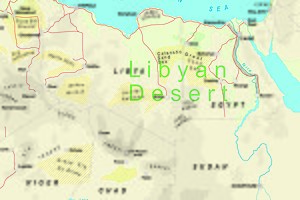
Libyan Desert
The term Libyan Desert began to appear widely on European maps in the last decades of the 19th century, typically identified as straddling the borders of present-day Egypt and Libya.
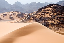
Sand plains, dunes, ridges, and some depressions (basins) typify the endorheic region, with no rivers draining into or out of the desert.
The Gilf Kebir plateau reaches an altitude of just over 1,000 m (3,300 feet), and along with the nearby massif of Jebel Uweinat is an exception to the uninterrupted territory of basement rocks covered by layers of horizontally bedded sediments, forming a massive sand plain, low plateaus, and dunes.
The main oases are Jaghbub and Jalo in east, in Cyrenaica, Kufra in the southeast, and Murzuk in the south, in Fezzan.
Other features are the Aswad al Haruj (the "Black Desert"), a large circular region of black volcanic shield in the centre of the country, and the Hamada al Hamra [de] (the "Red Desert") a rocky plateau to the west, on the Tunisian border, coloured by iron oxide deposits.
[1] North of the Gilf Kebir plateau, among the shallow peripheral dunes of the southern Great Sand Sea, is a field of Libyan desert glass.
The Libyan Desert is barely populated apart from the modern settlements at oases of the lower Cyrenaica region in southeastern Libya.
[2] Historically, "Libya" referred to an ill-defined area to the west of Ancient Egypt, whose boundary traditionally was the lake of Mareotis, outside Alexandria.
[3] Following the conquest of the territory by Italy during the Italo-Turkish War of 1911–12, the desert became the scene of a two-decade struggle between the Italians and the Senussi starting from 1915,[4] who were centred on the Jebel Akhdar in Cyrenaica and on the Kufra oasis.
Others, such as Ralph Bagnold and László Almásy also travelled in south-eastern Libya and southern Egypt, searching for the lost oasis of Zerzura.