Lichenometry
In archaeology, palaeontology, and geomorphology, lichenometry is a geomorphic method of geochronologic dating that uses lichen growth to determine the age of exposed rock, based on a presumed specific rate of increase in radial size over time.
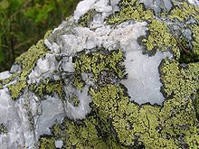
The measured growth rates of R. geographicum tends to fall within the range of 0.9–0.3 millimeter per year, depending on several factors, including the size of the lichen patch.
[8] Lichenometry can provide dates for glacial deposits in tundra environments, lake level changes, glacial moraines, trim lines, palaeofloods,[9] rockfalls, seismic events associated with the rockfalls,[2] talus (scree) stabilization and former extent of permafrost or very persistent snow cover.
[10] It has also been explored as a tool in assessing the speed of glacier retreat due to climate change.
[11] Among the potential problems of the technique are the difficulty of correctly identifying the species, the delay between exposure and colonization, the varying growth rates from region to region, growth rates not always being constant over time and depend uuon substrate texture and composition, the climate, and determining the lichen that is the largest.