List of ecoregions in Arkansas
The Commission's 1997 report, Ecological Regions of North America, provides a spatial framework that may be used by government agencies, non-governmental organizations, and academic researchers as a basis for risk analysis, resource management, and environmental study of the continent's ecosystems.
[1] Ecoregions may be identified by similarities in geology, physiography, vegetation, climate, soils, land use, wildlife distributions, and hydrology.
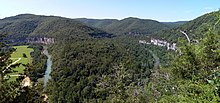
There are 32 Level IV ecoregions in Arkansas,[2] many of which continue into adjacent areas in the neighboring states of Oklahoma, Mississippi, Missouri, Louisiana, Tennessee, and Texas.
The task of defining and mapping these ecoregions was carried out by the United States Environmental Protection Agency (EPA) Region 6, EPA-National Health and Environmental Effects Research Laboratory (Corvallis, Oregon), and the Multi-Agency Wetland Planning Team.
Though often simplistically split into halves from southwest to northeast, with "uplands" in the northwest half and "lowlands" in the southeastern half, the CEC system of levels reveals the diverse forests and floodplains, prairies and plateaus, ridges and river bottoms, and loess hills and lowlands of Arkansas.