List of volcanic eruptions in Iceland
An operation was mounted to cool the advancing lava flow by pumping sea water onto it, which was successful in preventing the loss of the harbour.
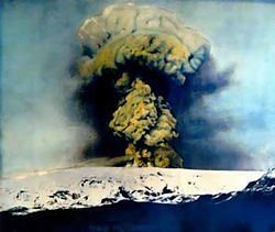
- Eyjafjallajökull, (E15),[11] An ice cap covers the caldera, erupts relatively frequently since the Last Glacial Period, most recently in 2010 disrupting international travel.
- Fagradalsfjall; is an active tuya volcano formed in the Last Glacial Period on the Reykjanes Peninsula,[14][15] around 40 kilometres (25 mi) from Reykjavík.
- Festarfjall, an exposed tuya mountain on the south coast of the Reykjanes Peninsula near the Fagradalsfjall volcanic system and Grindavík.
The flat topped volcano formed under the ice-sheet in the Last Glacial Period on the Reykjanes Peninsula,[14] It has been bisected vertically by coastal erosion, to expose its inner structure, including lava layers and an intrusive magma dyke.
As of 2020, the place where the line crosses the island is close to the northern tip and by the middle of the 21st century it will pass north of Grimsey altogether.)
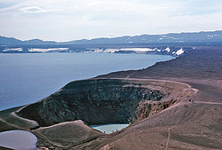
- Kerið is a volcanic crater lake located in the Grímsnes area in south Iceland, along the Golden Circle.
It is one of several crater lakes in the area, known as the Western Volcanic Zone, created as the land moved over a localized hotspot, but it has the most visually recognizable caldera still intact.
Although originally believed to have been formed by a volcanic explosion, studies of the Grímsnes region failed to find any supporting evidence.
- Grímsvötn; an active volcano with a (partially subglacial) fissure system located in Vatnajökull National Park.
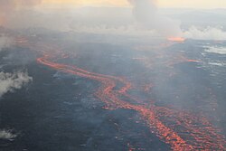
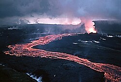
- Holuhraun, A lava field just north of the Vatnajökull ice cap, in the Icelandic Highlands, in Suður-Þingeyjarsýsla, Northeastern Region.
- Hvannadalshnúkur, a pyramidal peak on the northwestern rim of the summit crater of the Öræfajökull volcano in Vatnajökull National Park, Iceland.
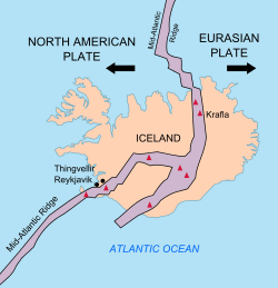
Iceland's location astride the Mid-Atlantic Ridge, where the Eurasian and North American Plates are moving apart, is partly responsible for this intense volcanic activity, but an additional cause is necessary to explain why Iceland is a substantial island while the rest of the ridge mostly consists of seamounts, with peaks below sea level.
The presence of water in magma reduces the melting temperature, which may also play a role in enhancing Icelandic volcanism.
Part of a large tuya volcano system with hot springs and rivulets, as well as red volcanic rhyolite stone.
- Kolbeinsey, is a small basalt islet, devoid of vegetation, in the Greenland Sea located 105 kilometres (55 nautical miles) off the northern coast of Iceland, 74 km (40 nmi) north-northwest of the island of Grímsey.
- Krakatindur, a volcano in the county of Rangárvallasýsla, located east of Hekla, it is part of the Nýjahraun lava field.
[55] The eight-month emission of sulfuric aerosols resulted in one of the most important climatic and socially significant natural events of the last millennium.
- Nýey, was a small, uninhabited island that formed in 1783 due to an underwater eruption in the Mid-Atlantic Ridge southwest of Reykjanes, Iceland.
[66][67][68][69] No volcanic eruption had occurred for 815 years on the Peninsula until 19 March 2021 when a fissure vent appeared in Geldingadalir to the south of Fagradalsfjall mountain.
Located in the north-east part of Vatnajökull National Park, it has been dormant in the Holocene, but is known to have had repose times of over 100,000 years between eruptions.
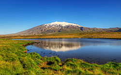
- Snæfellsjökull The 700,000-year-old stratovolcano, the only large central volcano on the Snæfellsnes Peninsula, has many pyroclastic cones on its flanks, plus upper-flank craters and lower-flank basaltic lava flows.
It was formed in a volcanic eruption which began 130 metres (430 feet) below sea level, and reached the surface on 14 November 1963.
- Thrihnukagigur (Thríhnákagígur), (Three Peaks Crater) is a dormant volcano in the volcanic system of Brennisteinsfjöll near Reykjavík, Iceland.
- Tjörnes, Fracture Zone is a submarine volcano situated northeast of Iceland, between the fjords of Öxarfjörður and Skjálfandi.
[89] This layer makes it possible to determine the exact dates of many archeological finds by so-called tephrochronology, like in the Reykjavík 871±2 museum.
Most of its lava fields have flowed in a northerly direction, with one branch of it reaching the valley of Bárðardalur, a distance of roughly 100 km.
See Chronology of Eruptions below: Stórhöfði peninsula 6,000 BP, Helgafell (volcano) 3,000 BC, Surtsey 1963, Jólnir 1963, Eldfell 1973
[192] It is proposed that the east–west line from the Grímsvötn volcano in the Mid-Iceland Belt (MIB) to the SVB shows the movement of the North American Plate over the Iceland hotspot.
[86] Includes: Geitlandsjökull, Geysir, Hengill (also listed under RFZ), Hlöðufell, Hveravellir, Skjaldbreiður, Stóra-Björnsfell, Þórisjökull.

(See Volcanic zones and systems )

See "Askja index"
See "Askja index"

See "Askja index"

See Bárðarbunga index , Holuhraun index

See Eldey index

See Eldey index

See Eldfell index , Vestmannaeyjar Islands index

See Eldfell index , Vestmannaeyjar Islands index

See Eldfell index , Vestmannaeyjar Islands index

See Eldfell index , Helgafell index , Vestmannaeyjar Islands index

See Eldgjá index

See Eldgjá index

See Esja index

See Esja index

See Esjufjöll index

See Eyjafjallajökull index

See Eyjafjallajökull index

See Eyjafjallajökull index

See Eyjafjallajökull index

See Eyjafjallajökull index


See Fagradalsfjall index

See Fagradalsfjall index

See Fagradalsfjall index

See Fagradalsfjall index

See Geirfuglasker index

See Gjálp index

Svínafellsjökull in the background.
It took some time to fill the subglacial lake of Grímsvötn and break the ice wall.
See Gjálp index

See Grímsey index

See Grímsnes index , Kerið index

See Grímsnes index , Kerið index

See Grímsnes index , Kerið index

See Grímsnes index , Kerið index

See Grímsvötn index

For individual eruptions:
- See Sundhnúkur eruptions images below,
- or follow Sundhnúkur index


See Hekla index

See Helgafell (on Snæfellsnes Peninsula) index

See Helgafell (on Heimaey) index , Vestmannaeyjar index

See Hengill index

See Hengill index

See Herðubreið index
See Holuhraun index

See Holuhraun index

See the Hvannadalshnúkur index

See Hveravellir index

See Hverfjall index

See Jólnir index

(See "Keilir index" )

(See "Kerlingarfjöll index" )

(See Kolbeinsey index )

(See Krafla index )

(See Krafla index )

(See Krafla index )

(See Krafla index )

(See Krafla index )

(See Krafla index )

(See Krafla index )

(See Krafla index )

(See Krafla index )

(See Kverkfjöll index )

(See Laki index , Lakagígar index )

(See "Laki index" , "Lakagígar index" )

(See "Laki index" , "Lakagígar index" )

(See "Laki index" , "Lakagígar index" )


(See below "Ljósufjöll index" )

(See Mývatn index , Mývatn fires index , Krafla fires index )

The tallest stratovolcano in Iceland is located in the Vatnajökull National Park .
(See Snæfell (Múlaþing) index )
(See Snæfellsjökull index )

(See Snæfellsjökull index )

(See Sundhnúkur index , Sundhnúkur 2023.12.18 )

(See Sundhnúkur index , Sundhnúkur 2023.12.18 )

(See Sundhnúkur index , Sundhnúkur 2024.01.14 )

(See Sundhnúkur index , Sundhnúkur 2024.02.08 )

(See Surtsey index , Vestmannaeyjar index )

(See Surtsey index , Vestmannaeyjar index )

(See Thórólfsfell index , Þórólfsfell index )

(See Thríhnákagígur index )

(See Thríhnákagígur index )

See Þingvellir index

See Þingvellir index

See Þingvellir index

See Þingvellir index

See Þingvellir index

(See Tindfjallajökull index )

(See Tjörnes Peninsula index )

(See Torfajökull index )

(See Trölladyngja index )

(See Tungnafellsjökull index )


(See Vatnajökull index )

(See Veiðivötn index )


