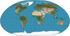
Loximuthal projection
[1] It is characterized by the fact that loxodromes (rhumb lines) from one chosen central point (the intersection of the central meridian and central latitude) are shown straight lines, correct in azimuth from the center, and are "true to scale" in the sense that distances measured along such lines are proportional to lengths of the corresponding rhumb lines on the surface of the Earth.
A loxodrome on the surface of the Earth is a curve of constant bearing: it meets every parallel of latitude at the same angle.
The loxodrome's whole length as it goes from the south pole to the north pole is fairly routinely seen to be πR csc θ where R is the radius of the Earth (in particular if the loxodrome goes straight east, it circles the Earth infinitely many times without getting closer to either pole, so its length is ∞.
Suppose one starts at the central point and travels a certain distance in a certain direction along this loxodrome and arrives at geographic location .
More than one loxodrome goes from the central point to p, but there is a unique shortest one: the one that does not cross the 180° meridian on its way from the central point to p. If one were to include loxodromes crossing the 180° meridian, one would get infinitely many images of the whole Earth, occupying the entire strip R × [−πR/2, πR/2].