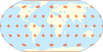
Robinson projection
It was specifically created in an attempt to find a good compromise to the problem of readily showing the whole globe as a flat image.
The meridians curve gently, avoiding extremes, but thereby stretch the poles into long lines instead of leaving them as points.
[1] Hence, distortion close to the poles is severe, but quickly declines to moderate levels moving away from them.
The straight parallels imply severe angular distortion at the high latitudes toward the outer edges of the map – a fault inherent in any pseudocylindrical projection.
However, at the time it was developed, the projection effectively met Rand McNally's goal to produce appealing depictions of the entire world.
Robinson did not specify any particular interpolation method, but it is reported that others used either Aitken interpolation (with polynomials of unknown degrees) or cubic splines while analyzing area deformation on the Robinson projection.
The European Centre for Disease Prevention and Control recommends using the Robinson projection for mapping the whole world.