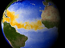
Main development region
[1][2] Tropical cyclone formation requires several factors, including: high humidity, low wind shear, and sufficiently warm sea surface temperatures.
Hurricanes do not form outside this range because nearer to the equator the Coriolis effect is not strong enough to create the tight circulation needed, and farther north the temperatures are too cool.
During the quiescent periods (3000–1400 BC, and 1000 AD to present), a more northeasterly position of the Azores High would result in more hurricanes being steered towards the Atlantic coast.
[7][8] Such a displacement of the Azores High is consistent with paleoclimatic evidence that shows an abrupt onset of a drier climate in Haiti around 3200 years ago,[9] and a change towards more humid conditions in the Great Plains during the late-Holocene as more moisture was pumped up the Mississippi Valley through the Gulf coast.
A 3,000-year proxy record from a coastal lake in Cape Cod suggests that hurricane activity has increased significantly during the past 500–1,000 years, just as the Gulf coast was amid a quiescent period of the last millennium.