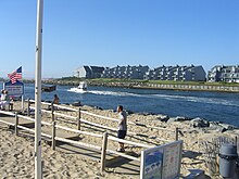
Manasquan River
It flows from western Monmouth County, beginning in Freehold Township, near the headwaters for the Manalapan Brook and Millstone River systems in the Raritan Basin, and flowing to the Atlantic Ocean, where it empties between the communities of Manasquan and Point Pleasant via the Manasquan Inlet.
[2] It widens greatly as it nears the ocean, making it ideal for boating, and is a very popular recreational area of the Jersey Shore.
It also marks the traditional boundary between North Jersey and South Jersey; it separates Monmouth and Ocean counties and marks the border between rich, fertile soil to the north and the sandier soil of the "Pine Barrens" to the south.
Situated in the middle of the river east of the New Jersey Route 70 highway bridge and adjacent to the former Point Pleasant Hospital site and Point Pleasant Canal entrance is a sizable island only accessible by boat that is a popular spot for picnics and recreation.
The island includes a sandy beach area and even used to have an improvised swing-set for youngsters which has been removed by the boro of Brielle, but is mainly covered with trees.