Mangaweka deviation
However, despite these obstacles surveyors were able to identify a route that kept the line to the west of the river along the cliff tops; albeit one that included a climb at each end of the section, a viaduct, and several tunnels.
At the same time concerns were also being voiced over State Highway 1 as the steep, narrow and twisting alignment was also prone to slips – having been built after the railway in the same area though further to the west – and naturally imposed speed restrictions that were exacerbated by heavier vehicles and creating bottlenecks.
From the south, the deviation leaves the old alignment at exit of the Mangaweka tunnel, and crosses SH1 and passes much closer to the settlement than it did previously.
[5] On 5 May 1975 200 tonnes of steel and concrete collapsed to the valley floor during construction of the South Rangitikei viaduct, bringing about a revision of the Ministry of Works and Development's Code of Practice for Falsework and Formwork.
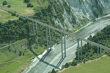
[6] The line then runs along the eastern river terrace for about 2 km, firstly through a lengthy cutting and then across the Blind Gully embankment (New Zealand's largest) before crossing the Kawhatau (73-m high over the Kawhatau River) and North Rangitikei (81-m high) viaducts in quick succession; the North Rangitikei viaduct is the highest on the NIMT.
For most travellers the most visible remnant of the old line are the bases of the Mangaweka viaduct which sit on the hillsides on each side of SH1 just north of the railway overpass.
The formation can still be followed either side of where the viaduct stood, though to the south it is slowly being reclaimed by bush and the tunnel at the top of the climb has been almost totally blocked by a slip at the northern portal.