Exploration of Mars
Probes sent from Earth, beginning in the late 20th century, have yielded a large increase in knowledge about the Martian system, focused primarily on understanding its geology and habitability potential.
[8] In April 2024, NASA selected several companies to begin studies on providing commercial services to further enable robotic science on Mars.
Early telescopic observations revealed color changes on the surface that were attributed to seasonal vegetation and apparent linear features were ascribed to intelligent design.
Further telescopic observations found two moons, Phobos and Deimos, polar ice caps and the feature now known as Olympus Mons, the Solar System's tallest mountain.
[11][12] The minimum-energy launch windows for a Martian expedition occur at intervals of approximately two years and two months (specifically 780 days, the planet's synodic period with respect to Earth).
Beagle 2 was located in January 2015 by the HiRise camera on NASA's Mars Reconnaissance Orbiter (MRO) having landed safely but failed to fully deploy its solar panels and antenna.
[31][32] In early 2004, the Mars Express Planetary Fourier Spectrometer team announced the orbiter had detected methane in the Martian atmosphere, a potential biosignature.
[34] Spirit rover (MER-A) was active until 2010, when it stopped sending data because it got stuck in a sand dune and was unable to reorient itself to recharge its batteries.
After launch, the third stage pumps on both launchers were unable to develop enough pressure to commence ignition, so Earth parking orbit was not achieved.
[49] Mars 7 probe separated prematurely from the carrying vehicle due to a problem in the operation of one of the onboard systems (attitude control or retro-rockets) and missed the planet by 1,300 kilometres (8.7×10⁻⁶ au).
The new data meant redesigns for then planned Martian landers, and showed life would have a more difficult time surviving there than previously anticipated.
When the storm cleared sufficiently for Mars' surface to be photographed by Mariner 9, the pictures returned represented a substantial advance over previous missions.
For example, Nix Olympica was one of only a few features that could be seen during the planetary duststorm, revealing it to be the highest mountain (volcano, to be exact) on any planet in the entire Solar System, and leading to its reclassification as Olympus Mons.
[67][68] The Viking orbiters revealed that large floods of water carved deep valleys, eroded grooves into bedrock, and traveled thousands of kilometers.
After a year and a half trimming its orbit from a looping ellipse to a circular track around the planet, the spacecraft began its primary mapping mission in March 1999.
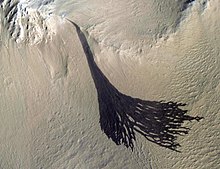
[75] Among key scientific findings, Global Surveyor took pictures of gullies and debris flow features that suggest there may be current sources of liquid water, similar to an aquifer, at or near the surface of the planet.
New temperature data and closeup images of the Martian moon Phobos showed that its surface is composed of powdery material at least 1 metre (3 feet) thick, caused by millions of years of meteoroid impacts.
[77] Faulty software uploaded to the vehicle in June 2006 caused the spacecraft to orient its solar panels incorrectly several months later, resulting in battery overheating and subsequent failure.
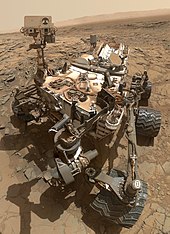
The mission's scientific objective was to search for and characterize a wide range of rocks and soils that hold clues to past water activity on Mars.
[citation needed] The ESA Rosetta space probe mission to the comet 67P/Churyumov-Gerasimenko flew within 250 km of Mars on February 25, 2007, in a gravitational slingshot designed to slow and redirect the spacecraft.
In August 2012, NASA selected InSight, a $425 million lander mission with a heat flow probe and seismometer, to determine the deep interior structure of Mars.
The US$720 million spacecraft was built by Lockheed Martin under the supervision of the Jet Propulsion Laboratory, launched August 12, 2005, and entered Mars orbit on March 10, 2006.
It was injected into Mars orbit on 19 October 2016 to gain a better understanding of methane (CH4) and other trace gases present in the Martian atmosphere that could be evidence for possible biological or geological activity.
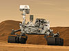
The car-size rover weighs about 1 ton, with a robotic arm that reaches about 7 feet (2.1 m), zoom cameras, a chemical analyzer and a rock drill.
Recordings consisted of five hours of Martian wind gusts, rover wheels crunching over gravel, and motors whirring as the spacecraft moves its arm.
[146] On December 2, 2014, NASA's Advanced Human Exploration Systems and Operations Mission Director Jason Crusan and Deputy Associate Administrator for Programs James Reuthner announced tentative support for the Boeing "Affordable Mars Mission Design" including radiation shielding, centrifugal artificial gravity, in-transit consumable resupply, and a lander which can return.
[154][155][156] To this end, the company is developing Starship, a spacecraft capable of crew transportation to Mars and other celestial bodies, along with its booster Super Heavy.
[157] Starship is planned to have a payload of at least 100 tonnes[158] and is designed to use a combination of aerobraking and propulsive descent, using fuel produced from a Mars (in situ resource utilization) facility.
Mars 96, an orbiter launched on November 16, 1996, by Russia failed, when the planned second burn of the Block D-2 fourth stage did not occur.
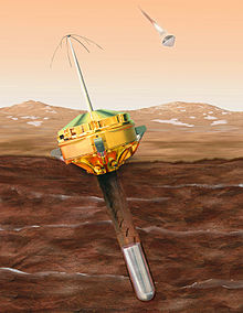
[171] The European Space Agency has also attempted to land two probes on the Martian surface; Beagle 2, a British-built lander that failed to deploy its solar arrays properly after touchdown in December 2003, and Schiaparelli, which was flown along the ExoMars Trace Gas Orbiter.


 Clickable image:
Clicking on the labels will open a new article.
Clickable image:
Clicking on the labels will open a new article.


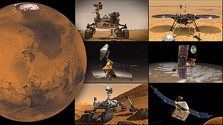
2001 Mars Odyssey · Mars

Mars Express · Mars