Mayon
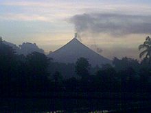
[10] The concave profile, a hyperbolic sine curve of the volcano is due to the balance between erosion and eruption, defined by the angle of repose of ash.
The viscid mass bubbled quietly but grandly, and overran the border of the crater, descending several hundred feet in a glowing wave, like red-hot iron.
Gradually, fading as the upper surface cooled, it changed to a thousand sparkling rills among the crevices, and, as it passed beyond the line of complete vision behind the woods near the base, the fires twinkled like stars or the scintillations of a dying conflagration.
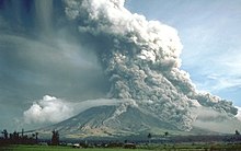
[20] But in 1993, pyroclastic flows killed 79[14] people, mainly farmers, during the eruption[21] that also forced 50,000 residents evacuated, according to the Albay provincial government.
[23] On February 24, PHIVOLCS raised its status to the highest, Alert Level 5, with at least eight towns and one city warned of possible explosions with ash and lava flows, and several thousands forced to evacuate even outside identified danger zones.
[25][26] The National Disaster Risk Reduction and Management Council (NDCC)reported that the 2000 eruption displaced 14,114 families (68,426 persons) and damaged at least ₱89-million worth of property and crops.
The decrease in key parameters such as seismicity, sulfur dioxide emission rates and ground inflation all indicated a waning condition.
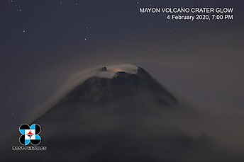
The slowdown in the eruptive activity was also evident from the decrease in intensity of crater glow and the diminishing volume of lava extruded from the summit.
PHIVOLCS maintained the Alert Status at Level 2, but later warned that with the approach of tropical cyclone international codename Mirinae, the danger of lahars and possible crater wall collapse would greatly increase and all specified precautions should be taken.
[34] At 8 pm on December 14, after 83 volcanic quakes in the preceding 24 hours[35] and increased sulfur dioxide emissions, PHIVOLCS raised the Alert status to Level 3.
[41] No civilian was permitted within the 8 km danger zone, which was cordoned off by the Philippine military who actively patrolled to enforce the "no-go" rule and to ensure no damage or loss of property of those evacuated.
[42] Alert level 4 was maintained as the volcano remained restive through December, prompting affected residents to spend Christmas and the New Year in evacuation centers.
"[52] Following the declaration of alert level 3 for the volcano, the United States issued an advisory cautioning its nationals from traveling to Mayon.
[54] The Albay provincial government ordered the local military to add more checkpoints, place roadblocks and arrest tourists caught traveling inside the 8-kilometer (5.0 mi) danger zone.
The Commission on Human Rights allowed the use of emergency measures and gave the authorities clearance to forcibly evacuate residents who refused to leave.
[43] Military vehicles were used to transport the evacuees back to their homes, while food supplies and temporary employment through the Department of Social Welfare and Development (DSWD) were provided to the heads of each family.
[57][58] As of January 3, 2010, the National Disaster Coordinating Council reported the overall cost of humanitarian aid and other assistance provided by the government and non-government organizations (NGOs) has reached over 61 million pesos since the start of the eruption.
According to Butch Rivera of Bicol Regional Training and Teaching Hospital, the hikers died due to trauma in their bodies, and suffocation.
[67] Authorities were also able to rescue a Thai national who was unable to walk due to fatigue and had suffered a broken arm and burns on the neck and back.
[70] The government of the United Kingdom advised its nationals to follow the advisories given by the local authorities, and respect the 6 km permanent danger zone.
This event was preceded by inflations of the volcano (measured by precise leveling, tilt data, and GPS), and increases in sulfur dioxide gas emissions.
[75] On September 15, NASA's Moderate-Resolution Imaging Spectroradiometer (MODIS) detected thermal anomalies near Mayon's summit, consistent with magma at the surface.
[76] On September 16, provincial governor Joey Salceda said that the government would begin to "fast-track the preparation to evacuate 12,000 families in the 6–8 km extended danger zone", and soldiers would enforce the no-go areas.
[78] On January 13, at 4:21 pm (PST), a phreatic eruption occurred that propelled a grayish steam and ash plume approximately 2500 meters high that drifted to the southwest side of the volcano.
[102] On the night of June 15, the volcano registered its largest pyroclastic flow since the resumption of its activity, with ashfall affecting parts of Ligao and Guinobatan.
[110] On November 30, 2006, strong rainfall which accompanied Typhoon Durian produced lahars from the volcanic ash and boulders of the last eruption killing at least 1,266 people.
[115] PHIVOLCS also deploys electronic distance meters (EDMs), precise leveling benchmarks, and portable fly spectrometers to monitor the volcano's daily activity.
After some time, the volcano was chosen as the abode of the supreme god of the Bicolano people, Gugurang, who also chose Mayon as the repository of the sacred fire of Ibalon.
[111] On February 23, 2023, a twin engine Cessna 340 airplane owned by the Energy Development Corporation departed Bicol International Airport in the early morning on an executive flight to the capital Manila.
A few minutes after takeoff, while climbing to an altitude of 6,000 ft (1,800 m), it impacted the rocky slope of Mt Mayon located about 16 km (9.9 mi) north of the airport.