McCreary County, Kentucky
[2] The county is named for James B. McCreary, a Confederate war soldier and two-time Governor of Kentucky (1875–1879, 1911–1915).
In 1780, the Virginia legislature set aside all land in Kentucky County for soldiers who had served in the Revolutionary War.
Running from Jacksboro, Tennessee, to Point Isabel and Somerset, this pioneer road was simply an enlargement of the Tellico Trail, an Indian route that had been used for thousands of years.
Several other trails intersected this road, and led to the settlement of villages such as Pine Knot, Dripping Springs/Coolidge, and Flat Rock.
The economy of the times was based upon small-scale subsistence agriculture, timber products such as railroad ties and barrel staves, and small coal mines.
Access to distant markets for timber and coal caused the emergence of many small mining and logging companies.
From 1903 through the rest of the century, the territory of McCreary County was dominated and controlled by Stearns company interests.
Attempting to avoid financial losses during the Great Depression of the 1930s, the Stearns cluster of companies sold vast quantities of land to the U.S. Government, becoming part of what was to become the Cumberland National Forest in 1937.
In the 1970s, legislative action acquired additional lands in southern McCreary and Tennessee, creating the Big South Fork National River and Recreation Area in the mid-1970s.
[4] McCreary County lies on the western edge of the Cumberland Plateau, which constitutes the East Kentucky Coal Field.
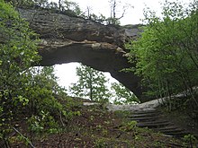
The county's bedrock is deeply incised by the Big South Fork of the Cumberland River and its tributaries, creating sheer cliffs, gorges, waterfalls, rock shelters, and natural stone arches.
Most of the geological underpinning of this region is capped with thick sandstone, and formidable coal seams are common in this formation.
Limited lands suitable for large-scale conventional agriculture exist, so the economy of the area has historically been centered upon extractive industries such as timber and mining.
[12][13] The economic history of McCreary County has been one of boom and bust, based upon the extractive resources of coal mining and timber.
Changes in the global economy have shifted a substantial percentage of the consumer garment market to production facilities outside the United States.
Those that remain in the county draw their work from military contracts, and the production of high-end consumer goods.
The Big South Fork Scenic Railway is presently in a major development project to add a steam locomotive and to extend the line.
The Big South Fork NRRA represents 196 square miles (508 km2) of land, of which approximately one-third is located in McCreary County.
The largest section of the park and its main Bandy Creek visitor center are located in Tennessee.
Due to a lack of organized activities, events, and recreational tourism opportunities, visitation on the Kentucky side does not fare well.