Menzenschwand
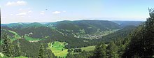
The valley landscape of Menzenschwand is shaped by the glacial streams of the Feldberg Glacier from several ice ages.
The main glacier, which was up to 300 metres thick, carved out trough-shaped valley of the Krunkelbach that starts at the large cwm west of the Herzogenhorn.
To the west of the Hinterdorf, in a cym below the Spießhorn (1348.9 metres), lies the circular Scheibenlechtenmoos, a raised mountain bog.
Valuable small bogs of various stages of development can also be found in the summit area of the Bärhalde north.
[3][4] At the same time, East Germany was one of the world's largest uranium producers through SDAG Wismut.