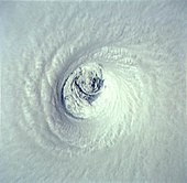
Mesovortex
Eyewall mesovortices are similar, in principle, to small "suction vortices" often observed in multiple-vortex tornadoes.
[5] Eyewall mesovortices are a significant factor in the formation of tornadoes after tropical cyclone landfall.
On 15 September 1989, during observations for Hurricane Hugo, Hunter NOAA42 accidentally flew through an eyewall mesovortex measuring 320 km/h (200 mph) and experienced crippling G-forces of +5.8Gs and -3.7Gs.
The winds ripped off the propeller de-icing boot and pushed the flight down to a perilous 1,000 ft (300 m) above sea level.
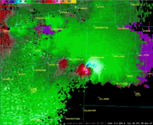
[citation needed] A mesocyclone is a type of mesovortex, approximately 1 to 10 km (0.6 to 6 mi) in diameter (the mesoscale of meteorology), within a convective storm.
[6] Mesocyclones are air that rises and rotates around a vertical axis, usually in the same direction as low pressure systems in a given hemisphere.
Associated low-level boundaries left behind can themselves cause convergence and vorticity that can increase the level of organization and intensity of any storms that do form.