Tropical Storm Hermine (1998)
[1] An area of low pressure developed over the northwestern Caribbean, and at about 1200 UTC on September 17, the system was sufficiently organized to be declared a tropical depression in the central Gulf of Mexico.
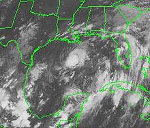
[1][2] Initially, the cloud pattern associated with the system featured a tight and well-defined circulation, as well as clusters of deep convection south of the center.
Due to the proximity of a large upper-level low-pressure area in the southern Gulf of Mexico, the surrounding environment did not favor intensification.
[7] Despite the wind shear, the depression attained tropical storm status at 1200 UTC on September 19; as such, it was named Hermine by the National Hurricane Center.
[9] A continually weakening storm, it moved ashore near Cocodrie, Louisiana at 0500 UTC on September 20 with winds of 40 miles per hour (64 km/h), and then deteriorated into a tropical depression.
[11] On September 17, the National Hurricane Center issued a tropical storm watch from Sargent, Texas to Grand Isle, Louisiana.
[15] Workers were evacuated from oil rigs in the Gulf of Mexico,[16] and energy futures rose substantially in anticipation of the storm, though when Hermine failed to cause significant damage, they retreated.
[18] In southern Florida, the combination of rainbands from Hermine and a separate upper-level cyclone in its vicinity produced up to 14.14 inches (359 mm) of rainfall.
[27] Captain Pat Yoes, of the St. Charles Parish Sheriff's Office, said that the storm "obviously ... played a part" in the man's death,[26] but Lieutenant Commander William Brewer of the United States Coast Guard told the press that he did not "think it was directly storm-related.
Rainfall of 4 to 5 inches (100 to 130 mm) caused localized flooding; in southern Walthall County, parts of Mississippi Highway 27 were under 1 foot (0.30 m) of water.
[31] Flash flood warnings were issued in Bibb and Shelby counties as northern Alabama experienced its first rainfall in the month of September.
[34] The remnants of the storm dumped 10.5 inches (27 cm) of rain on Charleston, South Carolina and rainfall of up to one foot was reported in other parts of the state.
The rain in Charleston led to over five feet of standing water in some neighborhoods, forcing several families to evacuate their mobile homes and stranding a number of vehicles.
The rain from the two storms flooded the swamps in south Louisiana, where it rapidly lost oxygen due to decaying plant matter.
Without sufficient oxygen, local fish population died quickly, filling waterways, particularly in the area of Lake Charles and Lafayette, according to the Louisiana Department of Wildlife and Fisheries.
The standing water after Hermine provided ideal hatching conditions for mosquitoes, who formed swarms large enough to kill livestock in the days after the storm.
The rains and standing water from the storm also prevented farmers from drying out soybeans for harvest and ruined sugar cane.

Tropical storm (39–73 mph, 63–118 km/h)
Category 1 (74–95 mph, 119–153 km/h)
Category 2 (96–110 mph, 154–177 km/h)
Category 3 (111–129 mph, 178–208 km/h)
Category 4 (130–156 mph, 209–251 km/h)
Category 5 (≥157 mph, ≥252 km/h)
Unknown