Meteorological history of Hurricane Gustav
The tropical disturbance which eventually spawned Hurricane Gustav gathered on August 16, southwest of the Cape Verde islands, but was slow to develop as it trekked west across the Atlantic.
Reaching Category 4 strength about 24 hours after having been upgraded to a hurricane, Gustav brushed the Isle of Youth and made landfall on Cuba's western's peninsula.
Briefly traveling over a warm eddy of the Gulf Stream's loop current it encountered moderate wind shear and cooling sea surface temperatures.
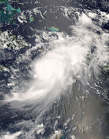
On August 18, 2008, a tropical wave which had left the coast of Africa five days previously,[1] developed into a significant low pressure area about 600 miles (970 km) west-southwest of the Cape Verde islands.
[7] Upon reaching the windward islands on August 23, bringing showers, thunderstorms, and generally squally weather,[8] wind shear over the system decreased and atmospheric conditions improved.
[12][13][1] The depression formed a small inner wind core 12 mi (19 km) in diameter which allowed it to rapidly organize, and on the afternoon of August 25 it was upgraded to a tropical storm and first given the name Gustav.
[1] After making landfall near Jacmel, Hurricane Gustav began traversing northwestward across the mountainous terrain of southwestern Haiti,[22][23] dumping heavy rains as it passed.
[24] With favorable atmospheric conditions[23] the storm maintained its hurricane intensity for several hours after landfall,[24] but the high mountains over which it was traveling disrupted its lower-level circulation.
[27][29][30] Although the storm's upper levels began experiencing moderate shear, and although parts of its circulation were still interacting with the mountains of southwestern Haiti, enough of Gustav's convection was over the Gulf of Gonâve that on the morning of August 27 its organization started to improve.
[31] That afternoon, as a broad ridge extended from the Gulf of Mexico into the western Atlantic Ocean,[32] Gustav began to slowly pull to the west,[33][34] away from the island of Hispaniola.
[42] Continuing west under influence of the same mid-level ridge that had dominated its steering thus far,[43] Gustav approached Jamaica[44] and its outer bands delivered heavy rains.
[54] Its low-level center reorganized over the open water and with little wind shear[55] a strengthening pattern emerged[56] which quickly returned Gustav to hurricane status that afternoon.
[59] Convective bands and upper-level outflow became well defined in all quadrants, wind shear decreased, and deep warm waters of the Caribbean Sean provided the perfect conditions for strengthening.
[1][75] Passing along the eastern coast of the Isle of Youth, Gustav wobbled slightly, possibly the result of an eyewall replacement cycle, and strengthened even further.
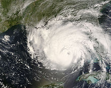
[76] Here, even as it brushed the island, Hurricane Gustav continued to strengthen, making a brief landfall with a central pressure of 943 mbar (27.8 inHg) and winds of 145 mph (233 km/h).
[82] Although it crosses the island in only a few hours,[79] the brief interaction caused the storm's eye to partially cloud-over[82] and its wind speeds fell to 140 mph (230 km/h)[83] as it entered that southeastern Gulf of Mexico that night.
[95] Its asymmetric appearance improved and its wind radius expanded, but by that night Gustav had moved off the eddy of the loop current and over slightly cooler water.
[97] Dry air intrusion from the south broke up the hurricane's eye, completely dissolving the eyewall[98] as heavy rain bands came ashore in the state of Louisiana.
[120] Through the morning of September 3, Tropical Depression Gustav briefly drifted north-northeastward under very weak steering currents,[121] but stalled completely over southwestern Arkansas that afternoon and spread heavy rain into the mid-Mississippi Valley.