Hurricane Bertha (2008)
On a west-northwest to northwest track, the depression intensified into Tropical Storm Bertha six hours formation and ultimately attained hurricane intensity on July 7.
Changes in wind shear and the storm's internal structure allowed Bertha to fluctuate in intensity over the next week as it passed very near Bermuda, but a track over cooler waters eventually caused the system to become an extratropical cyclone by July 20.
On July 1, the National Hurricane Center (NHC) began monitoring a vigorous tropical wave, accompanied by both a weak surface low and a large area of shower and thunderstorm activity, just off the western coast of Africa.
[1] The disturbance began to show signs of organization early on July 2;[2] satellite imagery the next morning showcased deep convection over the apparent center and increasingly pronounced banding features in the northwestern quadrant.
[3] Thus, in conjunction with satellite wind data, the storm was classified as a tropical depression by 06:00 UTC on July 3, located about 255 miles (410 km) south-southeast of Cabo Verde.
[3] Despite being embedded within an environment of low vertical wind shear, the storm passed over ocean temperatures near 77 °F (25 °C), and its overall appearance was characterized by intermittent bursts of deep convection near the center.
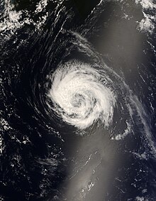
[6] Convection coalesced throughout July 6, and a series of microwave passes later that day indicated the formation of an eye-like feature, despite some tilt to Bertha's low- and mid-level circulations.
These unfavorable winds quickly slackened, allowing Bertha to regain Category 2 intensity by 18:00 UTC that day, before the hurricane began an eyewall replacement cycle.
Its wind field became extremely asymmetric and deep convection near the center dissipated,[11] indicative of an extratropical transition that Bertha completed by 12:00 UTC on July 20.
[4] On July 10, the Department of Parks placed high surf warning signs along the South Shore beaches as Bertha sent strong waves ahead of its path.

Tropical storm (39–73 mph, 63–118 km/h)
Category 1 (74–95 mph, 119–153 km/h)
Category 2 (96–110 mph, 154–177 km/h)
Category 3 (111–129 mph, 178–208 km/h)
Category 4 (130–156 mph, 209–251 km/h)
Category 5 (≥157 mph, ≥252 km/h)
Unknown