Mississippi River Delta
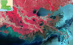
The river delta is a three-million-acre (4,700 sq mi; 12,000 km2) area of land that stretches from Vermilion Bay on the west, to the Chandeleur Islands in the east, on Louisiana's southeastern coast.
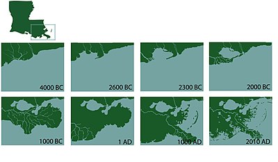
The shape of the current birdfoot delta reflects the dominance the river exerts over the other hydrologic and geologic processes at play in the northern Gulf of Mexico.
[9] The river's tributary channel was formed approximately 500 years ago and the Atchafalaya and Wax Lake deltas emerged around the middle of the twentieth century.
[10] Increased economic development and human habitation in the region created a desire to protect society from the threats posed by the river.
Although these changes successfully shielded many people from danger and enabled significant economic development in the region, they have proven to have profoundly negative effects on the downstream delta.
Robert Cavelier de La Salle claimed the territory around the mouth of the Mississippi River for France in 1682, and the region grew with importance with its strategic location for trade and security.
During this period, the economic and political significance of New Orleans and the mouth of the Mississippi River increased, and it became an integral part of the nation's farming industries.
Due to the influx of nutrient-rich soil from the Mississippi River, the delta is a prime area for the farming of sugar cane, cotton, and indigo—crops that were introduced into Louisiana farmlands during the pre-Civil War era.
The importance of navigation and trade on the Mississippi only increased after the Civil War, and like the river itself, this economic development eventually flowed into the delta.
[19] The Cajuns are another ethnic group in southern Louisiana; they primarily consider themselves to be descendants of the Acadian settlers who were expelled from Nova Scotia by the British after the French and Indian War, when France lost its North American colonies.
The Mississippi River Delta provides an array of natural habitats and resources that benefit not only the state of Louisiana and coastal region, but also the entire nation.
[22] In addition to the environmental factors, the Mississippi River Delta also provides numerous economic resources and benefits that are unique to the region.
There are a number of major industries in the Mississippi River Delta that drive the local and national economy, including: In total, the five Gulf Coast states generate around $34 billion annually in tourism.
Many diverse and rare species including indigo buntings, scarlet tanagers, yellow-crowned night herons and bald eagles call Louisiana home.
[37][41] Also found in the Mississippi River Delta are great egrets, glossy ibises, roseate spoonbills, wintering hummingbirds, birds of prey and wood storks.
The salt water weakens these freshwater ecosystems, making them more vulnerable to destruction by hurricanes and unable to withstand heavy storm surge.
In the absence of riverine sediment inputs to counteract it, net subsidence in the Mississippi River Delta occurs at a much faster rate than in other areas of the United States.
As global sea levels rise, the areas within the Mississippi River Delta that experience subsidence may permanently flood and become open water.
"[citation needed] This success, however, has come at a high cost for the region's natural landscapes and ecosystems, as the levees sever the connection between the river and surrounding wetlands.
Over time, 10 major navigation canals and more than 9,300 miles of pipelines were placed throughout coastal Louisiana, which currently serve around 50,000 oil and gas production facilities.
The dredging and oil and gas developments in the region affect the quality of water and drastically change the hydrology of the wetlands, depleting nutrients and sediments necessary for the survival and vitality of these areas.
Built in the 1960s between the Gulf of Mexico and the Port of New Orleans, it has contributed to the destruction of 27,000 acres of wetlands, allowing for salt water to enter freshwater ecosystems.
[50] It is also believed to have served as a "funnel" for Hurricane Katrina storm surge and contributed to a drastic increase of flooding in St. Bernard and the Lower Ninth Ward in New Orleans.
These structures block and trap the river's land-building sediment, cutting the replenishing nutrients and minerals needed for the stability and survival of the delta's unique ecosystems.
Research has been conducted in order to find the most feasible and effective restoration projects to mitigate further land loss and to implement rebuilding processes for the delta.
Studies have conservatively estimated that without sediment input, 4,000–5,000 square miles (10,000–13,000 km2) of the Mississippi Delta may be submerged by 2100, indicating a need for directed restoration efforts.
[53] Some of the important LCA Projects include: The state's Coastal Protection and Restoration Authority (CPRA) brought together national and international scientists and engineers to create a $50-billion, 50-year plan to save Louisiana's coast.
[59] Regardless, the plan was unanimously approved by the legislature in May 2012 and outlines 109 projects that intends to bring long-term benefits, resiliency and sustainability to the communities and ecosystems along the coast.
In 1926, the Bohemia Spillway was proposed as an engineering experiment attempting to create a mechanism to assist levees with controlling high water events.
[63] It was documented in newspaper reports that residents were fully compensated for the loss of their land by the Orleans Levee Board, but this has been reviewed in legal cases and proved false.


|
|
Salé-Cypremort | 4,600 years BP [ 11 ] |
|
|
Cocodrie | 4,600–3,500 years BP [ 11 ] |
|
|
Teche | 3,500–2,800 years BP [ 11 ] |
|
|
St. Bernard | 2,800–1,000 years BP [ 11 ] |
|
|
Lafourche | 1,000–300 years BP [ 11 ] |
|
|
Plaquemine | 750–500 years BP [ 11 ] |
|
|
Balize | 550 years [ 11 ] |