Monroe County, Arkansas
Historically covered in forest, bayous, swamps, and grasslands, the area was cleared for agriculture by early European-American settlers who used enslaved African Americans to do the work and to cultivate cotton.
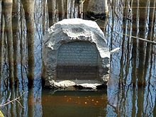
[4] Shortly after the United States had completed the Louisiana Purchase, officials began to survey the territory at a site near the intersection of Monroe, Phillips, and Lee counties.
From forested wetlands in what would become southern Monroe County, approximately 900,000 square miles (2,300,000 km2) of land would be explored after President James Madison commissioned a survey of the purchase area.
The point was commemorated in 1961 by the Arkansas General Assembly as part of Louisiana Purchase State Park.
[6] After the war, during Reconstruction, there was a high level of violence by insurgent whites seeking to suppress the rights of freedmen and to keep them from voting.
Four military districts were operated for four years in an effort to suppress guerrilla insurgency by white paramilitary groups, such as the Ku Klux Klan and others.
At the turn of the century, the state legislature passed measures that effectively disenfranchised most blacks for decades.
The Equal Justice Initiative reported in 2015 that the county had 12 lynchings of African Americans from 1877 to 1950,[8] most in the decades near the turn of the 20th century.
[8] To escape the violence, thousands of African Americans left the state in the Great Migration to northern and western cities, especially after 1940.
Large portions of Monroe County are also within the Grand Prairie, a subdivision of the Arkansas Delta known today for rice farming and aquaculture.
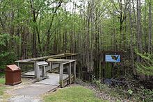
[9] Prior to settlement, Monroe County was densely forested, with bayous, sloughs, and swamps crossing the land.
Seeking to take advantage of the area's fertile soils, settlers cleared the land to better suit row crops.
Water is an extremely important part of Monroe County's geography, history, economy, and culture.
The many rivers, streams, ditches, sloughs and bayous crossing the county have featured prominently since prehistoric times.
Native American tribes settled near them and peoples such as the Quapaw constructed burial mounds at Indian Bay in extreme southern Monroe County (today preserved as Baytown Site).
Control of the White River lead to military action in the county during the Civil War, including a gunboat battle at Clarendon in 1864.
The Flood of 1927 damaged much of the county's settlements along the White, and inundated Clarendon when the levees protecting the city failed on April 20.
The quorum court is the legislative branch of the county government and controls all spending and revenue collection.
Prior to 2000, Monroe was considered an "ancestral" Democratic county, with exceptions for the 1972 and 1984 landslides of Richard Nixon and Ronald Reagan, respectively.
Over the past few election cycles Monroe has trended a bit more to the Republican Party, albeit with less fervor than its neighboring counties.
However, the United States census does list Arkansas population based on townships (sometimes referred to as "county subdivisions" or "minor civil divisions").
[27] Frank Federer Memorial Airport in southeast Brinkley had 22,000 GA operations in the twelve-month period ending August 31, 2015.
[30] The Arkansas Department of Health is responsible for the regulation and oversight of public water systems throughout the state.