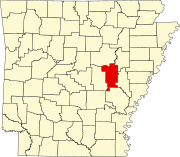
Prairie County, Arkansas
[3] Prairie County is served by two public owned/public use general aviation airports and six potable water systems.
Des Arc was partly destroyed, and a local historian estimated that not more than 15 horses were left in the county by the war's end.
Stern's Medlar, a previously unknown plant species, was discovered in Prairie County as recently as 1990.
The plant is critically endangered, with only 25 known specimens, all growing within a single small wood, now protected as the Konecny Grove Natural Area.
[6] Prior to settlement, Prairie County was large, flat grassland distinct from the swamps and bayous in the nearby Delta.
Although cotton and other row crops grew well in the Prairie's silty loam soil, rice production changed the cultivation patterns in the county at the turn of the nineteenth century.
[Note 1] Another large land use in Prairie County is the Cache River NWR and Wattensaw Wildlife Management Area (WMA), owned by the United States Fish and Wildlife Service and Arkansas Game and Fish Commission, respectively.
Prairie County experiences all four seasons, although summers can be extremely hot and humid and winters are mild with little snow.
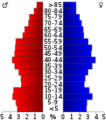
[9] As of the 2020 United States census, there were 8,282 people, 3,776 households, and 2,495 families residing in the county.
The economy of Prairie County is primarily agricultural (25.6%), followed by government employees (14.3%), and professional services (14.3%).
The quorum court is the legislative branch of the county government and controls all spending and revenue collection.
Representatives are called justices of the peace and are elected from county districts every even-numbered year.
[21][22] Since the late 20th century, the majority-white Prairie County has traditionally supported Republican Party presidential candidates, except when an alternative from another Southern state has been present.
[23] In Congress, Arkansas has been represented by two Republican senators (John Boozman and Tom Cotton) since January 3, 2015, ending a long history of Democratic hegemony.
Each township includes unincorporated areas; some may have incorporated cities or towns within part of their boundaries.
However, the United States census does list Arkansas population based on townships (sometimes referred to as "county subdivisions" or "minor civil divisions").
Each town or city is within one or more townships in an Arkansas county based on census maps and publications.
[29] The Arkansas Department of Health is responsible for the regulation and oversight of public water systems throughout the state.
Des Arc Waterworks has the largest retail population (3,882), followed by Hazen (1,600), and East Prairie County PWA (699).