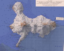
Mount Erebus
Scientific study of the volcano is also facilitated by its proximity to McMurdo Station (U.S.) and Scott Base (New Zealand), both sited on the same island around 35 km away.
The oldest eruptive products consist of relatively undifferentiated and nonviscous basanite lavas that form the low broad platform shield of Erebus.
A 1991 paper shows that these particles condense from the volcano's emissions that include 80 grams of gold vapor daily.
[11][12] Researchers spent more than three months during the 2007–08 field season installing an atypically dense array of seismometers around Mount Erebus to listen to waves of energy generated by small, controlled blasts from explosives they buried along its flanks and perimeter, and to record scattered seismic signals generated by lava lake eruptions and local ice quakes.
By studying the refracted and scattered seismic waves, the scientists produced an image of the uppermost (top few km) of the volcano to understand the geometry of its "plumbing" and how the magma rises to the lava lake.
[15] The ice caves associated with the fumaroles are dark, in polar alpine environments starved in organics and with oxygenated hydrothermal circulation in highly reducing host rock.
Organics can only come from the atmosphere, or from ice algae that grow on the surface in summer, which may eventually find their way into the caves through burial and melting.
[21] Mount Erebus was discovered on 27 January 1841 (and observed to be in eruption),[22] by polar explorer Sir James Clark Ross on his Antarctic expedition, who named it and its companion, Mount Terror, after his ships, HMS Erebus and HMS Terror (which were later used and lost by Sir John Franklin on his disastrous Arctic expedition).
Present with Ross on HMS Erebus was the young Joseph Hooker, future president of the Royal Society and close friend of Charles Darwin.
[23] The mountain was surveyed in December 1912 by a science party from Robert Falcon Scott's Terra Nova expedition, who also collected geological samples.
[24] Mount Erebus' summit crater rim was first achieved by members of Sir Ernest Shackleton's party; Professor Edgeworth David, Sir Douglas Mawson, Dr Alister Mackay, Alex Lagasse, Jameson Adams, Dr Eric Marshall and Phillip Brocklehurst (who did not reach the summit), on March 10, 1908.
[25] On 19–20 January 1991, Charles J. Blackmer, an iron-worker for many years at McMurdo Station and the South Pole, accomplished a solo ascent in about 17 hours completely unsupported, by snow mobile and on foot.
Dante successfully scaled a significant portion of the crater before technical difficulties emerged with the fibre-optic cable used for communications between the walker and base station.
[29] The Air New Zealand flyover service, for the purposes of Antarctic sightseeing, was operated with McDonnell Douglas DC-10-30 aircraft and began in February 1977.
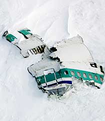
[31] Further investigation of the crash showed a navigational error in flight documentation by Air New Zealand and a cover-up that resulted in about $100 million in lawsuits.
During the Antarctic summer, snow melt on the flanks of Mount Erebus continually reveals debris from the crash that is visible from the air.
The topographic feature that rises to about 3,750 metres (12,300 ft) high and forms the primary summit crater of Mount Erebus.
The name derives from a nearby United States Coast Guard (USCG) HH-52A helicopter (CG 1404) which lost power and crashed while enroute from McMurdo Station to Cape Bird, Jan. 9, 1971.
A prominent outcropping of jumbled rocks, 3,633 metres (11,919 ft) high, formed as a lava flow on the northwest upper slope of the active cone of Mount Erebus.
So named, probably for its curved shape, by Frank Debenham of the British Antarctic Expedition, 1910-13, who made a plane table survey in 1912.
A peak rising to about 1,600 metres (5,200 ft) high on the northeast slope of Mount Erebus, 3.6 nautical miles (6.7 km; 4.1 mi) east of the summit of Fang Ridge.
On November 28, 1979, an Air New Zealand McDonnell Douglas DC-10 aircraft on a scenic flight from Auckland crashed near this peak claiming the lives of 237 passengers from eight countries and a crew of 20.
Te Puna Roimata Peak (meaning spring of tears) was named by the New Zealand Geographic Board (NZGB) in 2000.
From McMurdo Sound it appears as a perfect pyramid of black rock, standing out as a splendid mark against the background of the ice and almost on a line from Cape Royds to the crater of Mount Erebus.
Kyle, named by United States Advisory Committee on Antarctic Names (US-ACAN) (2000) after Katherine V. Cashman, United States Antarctic Research Program (USARP) team member on Mount Erebus in 1978-79 while a Fulbright scholar at Victoria University of Wellington; worked again on Mount Erebus, 1988-89; later Professor of Geology, University of Oregon.
A prominent rock cliff that stands out from the ice-covered southwest slopes of Mount Erebus, situated 6 nautical miles (11 km; 6.9 mi) east of Cape Barne.
A narrow broken ridge 2 nautical miles (3.7 km; 2.3 mi) south of Williams Cliff on Ross Island.
The feature rises to about 1,000 metres (3,300 ft) high and marks a declivity along the north flank of broad Turks Head Ridge, from which ice moves to Pukaru Icefalls.
From 1981, many Tech students under the direction of Philip R. Kyle, have undertaken graduate research projects (thesis and dissertation) on Mount Erebus.
Kyle, named by US-ACAN (2000) after Grazyna Zreda-Gostynska, who worked on Mount Erebus in 1989-90 as a member of the New Mexico Institute of Mining and Technology team.