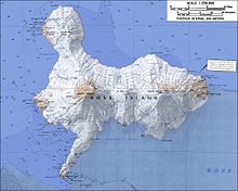
Mount Bird
It was mapped by the British National Antarctic Expedition, 1901–04, under Robert Falcon Scott, and apparently named by them after Cape Bird.
It descends steeply in the valley north of Trachyte Hill and Harrison Bluff in the center of the ice-free area on the lower western slopes of Mount Bird.
Mapped and so named by the New Zealand Geological Survey Antarctic Expedition (NZGSAE), 1958–59, because of the marine shell content of the moraines.
A small stream flowing west between Trachyte and Cinder Hills to the north end of Romanes Beach.
A meltwater stream which flows from the ice-free lower west slopes of Mount Bird, to the south of Alexander Hill, and over steep sea cliffs into Wohlschlag Bay.
A western lobe of the Mount Bird icecap, descending steeply into Wohlschlag Bay 1 nautical mile (1.9 km; 1.2 mi) south of Cinder Hill.
Mapped and so named by the NZGSAE, 1958-59, because of the Quaternary glacial period marine shells carried by the glacier and deposited in terminal moraines.
It rises to about 1,200 metres (3,900 ft) high and, like Takahe Nunatak close NE, appears to be part of an ice-covered crater rim.
A rugged nunatak 2.2 nautical miles (4.1 km; 2.5 mi) north of the summit of Mount Bird.
Two parallel rock ridges 2.2 nautical miles (4.1 km; 2.5 mi) northwest of the summit of Mount Bird.
A prominent peak 1.4 nautical miles (2.6 km; 1.6 mi) north of the Mount Bird summit in northwest Ross Island.
A peak 1.6 nautical miles (3.0 km; 1.8 mi) northeast of the summit of Mount Bird in northwest Ross Island.
A peak 2.4 nautical miles (4.4 km; 2.8 mi) east-northeast of the summit of Mount Bird in northwest Ross Island.
A prominent steeply concial hill, 335 metres (1,099 ft) high, between McDonald Beach and the Mount Bird icecap.
A hill, 230 metres (750 ft) high, standing west of Mount Bird between Fitzgerald Stream and Shell Glacier.
A prominent dissected volcano, 305 metres (1,001 ft) high, consisting of layers of red basalt scoria and cinders and abundant olivine nodules, standing between Harrison Stream and Wilson Stream on the ice-free lower west slopes of Mount Bird.
A prominent hill, 470 metres (1,540 ft) high, just south of Shell Glacier in the center of the ice-free area on the lower west slopes of Mount Bird.
A hill, 1,100 metres (3,600 ft) high, located at the head of Shearwater Glacier, 2.2 nautical miles (4.1 km; 2.5 mi) west-southwest of the summit of Mount Bird in northwest Ross Island.
Named by New Zealand Geographic Board (NZGB) (2000) after Gordon Keys, leader of long term NZAP atmospheric research, 1985-95.
An ice-free coastal bluff rising to over 400 metres (1,300 ft) high between the terminus of Shearwater Glacier and Quaternary Icefall in northwest Ross Island.
As a Ph.D. student at Ohio State University, collected snow samples and short ice core on Ross Island to examine the volcanic record.
A line of several nunataks 1.2 nautical miles (2.2 km; 1.4 mi) southeast of the summit of Mount Bird.
It stands 2 nautical miles (3.7 km; 2.3 mi) southeast of the summit of Mount Bird in northwest Ross Island.
An extensive beach lying west of Inclusion Hill and 6 nautical miles (11 km; 6.9 mi) southwest of Cape Bird.
So named by the NZGSAE, 1958-59, because of periodic flooding by meltwater from the Cape Bird icecap, which has been destructive to nearby penguin rookeries.
[32] This article incorporates public domain material from websites or documents of the United States Geological Survey.