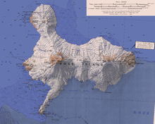
Mount Terror (Antarctica)
Kyle, named by Advisory Committee on Antarctic Names (US-ACAN) after Juergen Kienle (d.), Geophysical Institute, University of Alaska, Fairbanks, a United States Antarctic Project (USAP) team leader for the investigation of volcanic activity and seismicity on Mount Erebus in six field seasons, 1980-81 through 1985-86.
Named by Advisory Committee on Antarctic Names (US-ACAN) (2000) after Alexander L. Sutherland, Jr., Ocean Projects Manager, OPP, NSF, with responsibility for directing operations and logistics for United States Antarctic Project (USAP) research vessels from 1989; responsible for acquisition of the Research Vessel/Ice Breakers Nathaniel B. Palmer and Laurence M.
Two rock ridges, about 1,400 metres (4,600 ft) high, that are parallel and rise above the general ice mantle on the southeast slopes of Mount Terror.
This feature is east of the head of Eastwind Glacier and 4 nautical miles (7.4 km; 4.6 mi) northeast of Conical Hill.
A sharp rock peak 1.9 nautical miles (3.5 km; 2.2 mi) northeast of the summit of Mount Terror on Ross Island.
The feature rises to about 2,400 metres (7,900 ft) high and is central in three aligned summits 0.8 nautical miles (1.5 km; 0.92 mi) north of Mount McIntosh.
A north-south chain of summits, 5 nautical miles (9.3 km; 5.8 mi) long, located to the west and northwest of Mount Terror.
Kyle, named by Advisory Committee on Antarctic Names (US-ACAN) (2000) after Raymond L. Chuan who, as a scientist with the Brunswick Corporation, Costa Mesa, CA, undertook many airborne surveys of volcanic aerosols from Mount Erebus and also did sampling at the crater rim, 1983–84 and 1986–87; investigator (with Julie Palais) on a project which examined aerosols between Mount Erebus and the South Pole.
A prominent peak 1 nautical mile (1.9 km; 1.2 mi) east of Giggenbach Ridge in northeast Ross Island.
The peak rises to over 2,000 metres (6,600 ft) high 2.6 nautical miles (4.8 km; 3.0 mi) northwest of the summit of Mount Terror.
Named by Advisory Committee on Antarctic Names (US-ACAN) (2000) after biologist Donal T. Manahan, who worked eight seasons in Antarctica from 1983; United States Antarctic Project (USAP) prinicipal investigator in study of early stages (embryos larvae) of marine animals; chair, Polar Research Board, National Academy of Sciences, 2000.
Name by New Zealand Geographic Board (NZGB) (2000) after Major James R. M. Barker, officer in command at Scott Base, 1970–71; a NZAP manager, 1970-86.
Named by Advisory Committee on Antarctic Names (US-ACAN) (2000) after Kristin Larson, who has participated in support activities to United States Antarctic Project (USAP) from 1988, including two winters at McMurdo Station; supervisor, Eklund Biological Center and Thiel Labs, 1988 and 1992; supervisor, Crary Science and Engineering Center, 1992–95; editor, The Antarctican Society newsletter from 1996; later of staff of OPP, NSF.
The feature lies 1 nautical mile (1.9 km; 1.2 mi) south-southeast of Tent Peak and is reported to resemble a fossilized shark's tooth.
A somewhat isolated rock peak, about 600 metres (2,000 ft) high, that rises above the ice mantle southeast of Mount Terror.
A small but distinctive rock hill, 655 metres (2,149 ft) high, on the south slopes of Mount Terror, above Cape MacKay.