Mountains and hills of England
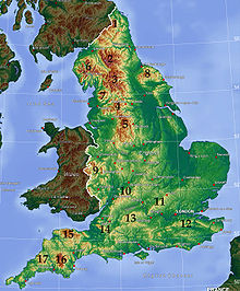
The highest and most extensive areas are in the north and west (including south-west), while the midlands, south-east and east of the country tend to be low-lying.
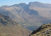
The highest peak is Scafell Pike, 978 m (3,209 ft) above sea level, and at least three other summits exceed 3,000 feet or 914.4 metres making them Furth Munros.
The Cheviot Hills lie north of the Border Moors, which extend into Scotland and could probably be considered part of either the Southern Uplands or the northern Pennines.
The North Pennines (an Area of Outstanding Natural Beauty, or AONB) lie south of Hadrian's Wall and the Tyne Gap, and east of the Lake District, from which they are separated by the Eden Valley.
These are younger rocks, mostly Carboniferous limestone, and the mountains are characterised by shallower slopes covered with moorland vegetation, culminating in Cross Fell at 893 m (2,930 ft).
South of this, the main line of the Pennines (often called "the backbone of England") continues into the Yorkshire Dales around the Stainmore Gap, a limestone-dominated area of broad valleys and moorland.
Wenlock Edge, running through the middle of the Shropshire Hills AONB, is a long, low ridge, which extends for over 15 miles (24 km).
The Malverns are made from some of the oldest rock in England (around 680 million years old) and extend some 8 miles (13 km) through two West Midlands counties Worcestershire and Herefordshire as well as northern Gloucestershire in the southwest.
Areas of lower hills in the Midlands include Cannock Chase in Staffordshire, Charnwood Forest in Leicestershire and the Lincolnshire Wolds.
Exmoor, in northern Somerset, and abutting the Bristol Channel, reaches 519 m (1,703 ft) at Dunkery Beacon, and is famous as the setting of Lorna Doone.