Early world maps
The developments of Greek geography during this time, notably by Eratosthenes and Posidonius culminated in the Roman era, with Ptolemy's world map (2nd century CE), which would remain authoritative throughout the Middle Ages.
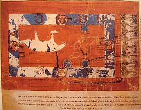
A recent analysis, published in the Bulletin of the French Prehistoric Society, has shown that the slab is a three-dimensional representation of the River Odet valley in Finistère, France.
According to the authors, the map probably was not used for navigation, but rather to show the political power and territorial extent of a local ruler's domain of the early Bronze Age.
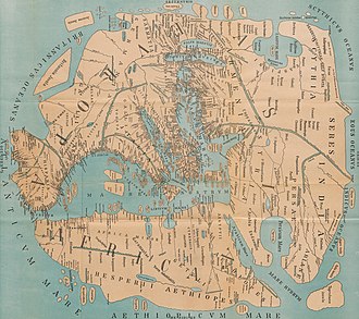
He thought that the inhabited world stretched in latitude from Thule (Shetland) to Agisymba (Tropic of Capricorn) and in longitude from the Isles of the Blessed to Shera (China).
Ptolemy followed Marinus in underestimating the circumference of the world; combined with accurate absolute distances, this led him to also overestimate the length of the Mediterranean Sea in terms of degrees.
His prime meridian at the Fortunate Isles was therefore around 10 actual degrees further west of Alexandria than intended, a mistake that was corrected by Al-Khwārizmī following the translation of Syriac editions of Ptolemy into Arabic in the 9th century.
Around 550 Cosmas Indicopleustes wrote the copiously illustrated Christian Topography, a work partly based on his personal experiences as a merchant on the Red Sea and Indian Ocean in the early 6th century.
A major feature of his Topography is Cosmas' worldview that the world is flat, and that the heavens form the shape of a box with a curved lid, a view he took from unconventional interpretations of Christian scripture.
Cosmas aimed to prove that pre-Christian geographers had been wrong in asserting that the earth was spherical and that it was in fact modelled on the Tabernacle, the house of worship described to Moses by God during the Jewish Exodus from Egypt.
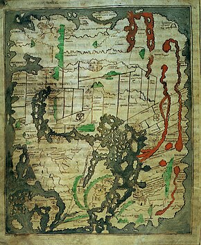
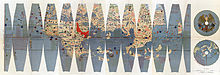
[23] The known world is represented in the form of a horseshoe, opening at the level of the Strait of Gibraltar, and surrounding the Mediterranean, with the Middle East at the top, Europe on the left and North Africa on the right.
[24] This map appears in a copy of a classical work on geography, the Latin version by Priscian of the Periegesis, that was among the manuscripts in the Cotton library (MS. Tiberius B.V., fol.
The date of drawing was formerly estimated at c. 992–994 CE, based on suggested links to the journey of Archbishop Sigeric of Canterbury from Rome[25] but more recent analysis indicates that, although the information was revised about that time, the map was probably drawn between 1025 and 1050.
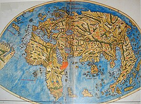
The Tabula Rogeriana was drawn by Al-Idrisi in 1154 for the Norman King Roger II of Sicily, after a stay of eighteen years at his court, where he worked on the commentaries and illustrations of the map.
The captions demonstrate clearly the multiple functions of these large medieval maps, conveying a mass of information on Biblical subjects and general history, in addition to geography.
It is believed that maps of this type were made since about the 1320s, but all earlier specimens have been lost, so the earliest survivor is the elaborate, colourful Da Ming Hunyi Tu, painted on 17 m2 (180 sq ft) of silk.
It also demonstrates the post-Mongol era stagnation of East Asian cartography as geographic information about the West was not updated until the introduction of European knowledge in the 16-17th centuries.
[35] Superficially similar to the Da Ming Hun Yi Tu (which has been less well known in the West because it is kept in closed archive storage) the Gangnido shows its Korean origin in the enlargement of that country, and incorporates vastly improved (though wrongly positioned, scaled and oriented) mapping of Japan.
The map depicts the main landmarks of the time, and figures such as the legendary Prester John in Africa, the Great Khan in China, "Xilam" (Ceylon) and Sumatra, and the design of a three-masted European ship in the Indian Ocean, something which had not occurred, suggesting that a sea-lane was a possibility.
The world map of Henricus Martellus Germanus (Heinrich Hammer), c. 1490, was remarkably similar to the terrestrial globe later produced by Martin Behaim in 1492, the Erdapfel.
The Juan de la Cosa, a Spanish cartographer, explorer and conquistador, born in Santoña in what was then the Kingdom of Castille, made several maps of which the only survivor is the Mappa Mundi of 1500.
The map is particularly notable for portraying a fragmentary record of the Brazilian coast, discovered in 1500 by Portuguese explorer Pedro Álvares Cabral who conjectured whether it was merely an island[39] or part of the continent that several Spanish expeditions had just encountered farther north (cf.
Around the north pole, Ruysch drew islands, based on reports in the book Inventio Fortunata of the English friar Nicholas of Lynne.
Along with a book they further incorporated, for the first time in history, the name America on a map, holding the strong opinion that it was a new continent that Amerigo Vespucci had discovered on his voyage and not only a few smaller islands as Christopher Columbus did in the West Indies.
The map is noteworthy for its apparent south-eastward extension of the American continent to depict a southern landmass that some controversially claim is evidence for early awareness of the existence of Antarctica.
Alternatively, it has been suggested that this is actually a record of the coast as far as Cape Horn, explored secretly by Portuguese navigators before 1507 (when it appeared on the Waldseemüller map) and bent south-eastward simply to fit on the parchment.
Europe and Central and South America are very precisely delineated, although Portuguese control of the African trade routes limited the accuracy of information on the Indian Ocean.
Incorporating information from the Magellan, Gomes, and Loaysa expeditions and geodesic research undertaken to establish the demarcation line of the 1494 Treaty of Tordesillas, the maps show for the first time the real extension of the Pacific Ocean and the continuous coast of North America.
The map is in Classical Chinese, with detailed annotations and descriptions of various regions of the world, a brief account of the discovery of the Americas, polar projections, scientific explanation of parallels and meridians, and proof that the Sun is bigger than the Moon.
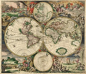
[43] Nova Totius Terrarum Orbis Geographica ac Hydrographica Tabula is a map of the world created by Hendrik Hondius in 1630, and published the following year at Amsterdam, in the atlas Atlantis Maioris Appendix.
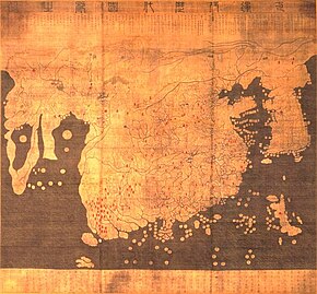
The map stretched from the Insulae Fortunatae (Canary Islands) in the top right to Andalusia (Europe) to Sus al Aqsa (Western Africa) in the left.