North Platte River
Shortly after passing Casper, the river turns to the east-southeast and flows about 350 miles (560 km) to the city of North Platte, Nebraska.
To get the two essentials, water and grass, for the traveler's animals the emigration trails nearly always followed river valleys across the North American continent.
The lack of American trappers and settlers in the contested Oregon Territory resulted in this early discovery being unused and nearly forgotten.
The rugged territory from Fort Laramie, Wyoming to Casper meant that the trails often deviated from the river to find an easier path and relied on streams draining into the North Platte for water.
The rugged Rocky Mountains Continental Divide surrounding Jackson County have at least twelve peaks over 11,000 feet (3,400 m) in height.
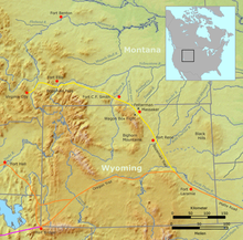
The North Platte River flows northward from Colorado into Wyoming through the popular rafting site – Northgate Canyon[10] which is along the western side of the Medicine Bow Mountains.
[11] Still further downstream about 50 miles (80 km) above Casper the North Platte is joined by the Sweetwater River to form the Pathfinder Reservoir.
Casper was established in 1888 east of the former site of Fort Caspar, which was built about 1859 during the mass migration along the Oregon, California, Mormon and Bozeman trails.
[14] Near what is now Casper was the location of several ferries that offered passage across the North Platte River during the summer "Trail season" starting about 1847.
In 1859, Louis Guinard built a toll bridge across the North Platte and a trading post near the original ferry's locations.
Historically, the North Platte River used to be up to a mile wide (1.6 km) in many places as evidenced by the old streambed and written records.
Today, by the time the North Platte reaches Paxton, Nebraska it is much smaller due to the extensive water taken from it for irrigation.