Local tangent plane coordinates
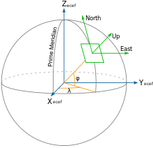
Local tangent plane coordinates (LTP) are part of a spatial reference system based on the tangent plane defined by the local vertical direction and the Earth's axis of rotation.
It consists of three coordinates: one represents the position along the northern axis, one along the local eastern axis, and one represents the vertical position.
Two right-handed variants exist: east, north, up (ENU) coordinates and north, east, down (NED) coordinates.
They serve for representing state vectors that are commonly used in aviation and marine cybernetics.
For movements around the globe, like air or sea navigation, the frames are defined as tangent to the lines of geographical coordinates: In many targeting and tracking applications the local East, North, Up (ENU) Cartesian coordinate system is far more intuitive and practical than ECEF or Geodetic coordinates.
In an airplane, most objects of interest are below the aircraft, so it is sensible to define down as a positive number.
The North, East, Down (NED) coordinates allow this as an alternative to the ENU.
The origin of this coordinate system is usually chosen to be a fixed point on the surface of the geoid below the aircraft's center of gravity.
[4] NED coordinates are similar to ECEF in that they're Cartesian, however they can be more convenient due to the relatively small numbers involved, and also because of the intuitive axes.
NED and ECEF coordinates can be related with the following formula: where
is the reference ECEF position (where the local tangent plane originates), and
is a rotation matrix whose rows are the north, east, and down axes.