November 2006 nor'easter
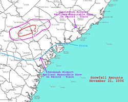
In addition, the earliest snowfall ever noted in both Charleston, South Carolina and Savannah, Georgia occurred on the southwest side of this cyclone.
A shortwave moved through the southern stream of the polar jetstream of the Westerlies, dropping temperatures in its wake across the southeast United States.
Surface pressure gradient between this cyclone and a sprawling high stretching around its periphery from New England into the Deep South led to strong winds in the Carolinas.
The cyclone deepened to a central pressure of 999 hectopascals (29.5 inHg) before swinging westward into the Outer Banks of North Carolina on November 22.
At this time, a trio of upper-level shortwaves were rotating around the main closed cyclone aloft, which spurred development of a new, weaker low pressure center offshore North Carolina.
The system then began accelerating east-northeast while continuing to slowly strengthen, passing offshore Atlantic Canada on November 24.
By the evening of November 27, its central pressure had increased to 957 hectopascals (28.3 inHg) while located a couple hundred miles south of Iceland.
On the Chesapeake Bay Bridge-Tunnel, officials restricted the types of vehicles that could cross the span between Virginia Beach and the Eastern Shore to cars and pickup trucks.
Poquoson Public Schools were closed, and the Midtown Tunnel between Norfolk and Portsmouth was shut down because of the possibility of flooding.
Sandbags surrounded buildings at Langley Air Force Base, which lies 11 feet (3.4 m) above sea level, and all computers and electrical equipment were waterproofed.
[3] The Maryland State Highway Administration worked to clear storm drains of branches and leaves and called in more patrollers to assist motorists in the event of an accident or stranded vehicle.
[6] Heavy rainfall fell throughout central and eastern North Carolina, with the maximum amount of 7.68 inches (195 mm) measured at Sandy Run.
This form of precipitation is rare for the area in mid-November, but was quickly replaced by driving rainfall as warmer air from the Atlantic pushed inland.
Steady rain persisted throughout the afternoon and evening of the 22nd, with a mix of showers and moderate-to-heavy mist occurring throughout Thanksgiving Day, November 23.
[17] Low level wind shear led to moderate delays of an hour or more at major airports within the megalopolis on the morning of November 22, the day before Thanksgiving in the United States.