Ontario Highway 7
Soon thereafter, that new tollway would act as justification for transferring the section of Highway 7 through the Greater Toronto Area (GTA) to regional governments.
A third transfer took place in Peterborough, briefly separating the route into three discontinuous segments, but has since been rectified by renumbering a section of Highway 7A.
In addition, work is underway to extend the Conestoga Parkway to New Hamburg as well as to build a new freeway between Kitchener and Guelph.
Upon entering the Sarnia city limits from the east on Highway 7, drivers encountered a plethora of motels and restaurants, the Sarnia Airport, and attractions such as Hiawatha Racetrack and Waterpark, earning the stretch between Modeland Road and Airport Road the nickname of the "Golden Mile".
[3] The current western segment of Highway 7 travels from Elginfield in Middlesex County in the southwest to the Halton - Peel border at Norval near Brampton; a distance of 152.6 kilometres (94.8 mi).
[4] A 23.4 km (14.5 mi) portion of this segment, from Waterloo Regional Road 51 south of Baden to Highway 85 in Kitchener is a freeway, forming part of the Conestoga Parkway.
Southwest of New Hamburg, the route curves northeast into Waterloo Region, eventually widening into the four-lane Conestoga Parkway east of Nafziger Road.
[6] Highway 7 exits Kitchener after crossing the Grand River, where it enters farmland again for the brief 10-kilometre (6 mi) journey to Guelph along Victoria Street and Woodlawn Road.
It exits the city along York Road after crossing the Speed River, travelling parallel to and south of the Goderich–Exeter Railway.
Old sections of Highway 7 bypassed by the new expressway still remain in use between Bathurst Street and Bayview Avenue, but reverted to their original name of Langstaff Road.
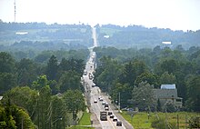
[9][10] Travelling east from Donald Cousens Parkway, Highway 7 exits the urbanized portion of Markham and enters the Greenbelt, a large tract of land north of the GTA restricted from development.
East of Lindsay, the route meanders southeast towards Peterborough, encountering the divided freeway Highway 115 southwest of the city.
It was constructed parallel to a CP Rail corridor (now abandoned east of Peterborough) that was built in the 1880s, and used hand-power to dig and build the road whenever possible.
The section east of Havelock to Perth, unlike the rest of the highway, travels through a relatively isolated area, with few services or residences along the route outside of the several towns that it connects.
In contrast to the surroundings west of there, this section is located in dense forest with numerous lakes and muskeg dotting the landscape.
It intersects the northern terminus of former Highway 38 near Sharbot Lake and later passes south of Maberly before exiting the Canadian Shield and reentering farmland.
It travels around the western and northern shorelines of Mississippi Lake before passing directly south of Carleton Place.
[17] On November 18, 1931, construction was accelerated between Madoc and Perth as a major depression-relief project when eight contracts were set to build the new route.
Over 2700 men blasted rock, dredged muskeg and endured a constant barrage of blood-sucking insects in order to construct this new link.
The majority of it followed along a Canadian Pacific right-of-way (now abandoned past the town of Havelock) which had been cleared in 1881, deviating at times to provide a better alignment, avoid large muskeg or to lessen excavation work, most of which was performed by hand.
[3] In the late 1990s and early 2000s, the Ministry of Transportation (MTO) "downloaded" (i.e., transferred responsibility for) several sections of Highway 7 to regional and county governments.
Finally, on January 25, 2007, the section between Markham Road and 185 m (607 ft) east of Donald Cousens Parkway, where the highway narrows to two lanes today, was transferred.
[27] The non-Highway 7 portions of Queen Street and Bovaird Drive west and east of Highway 410 are designated as Regional Roads 6 and 10 respectively.
[29][30][31] On August 22, 2006, work officially began on a project to expand Highway 7 between Ottawa and Carleton Place into a freeway through a process known as twinning,[32] in which a second carriageway is built parallel to an existing road and grade-separated interchanges constructed.
[36][37] Bot Construction was awarded the $73.2 million contract for the second phase, which included two interchanges, four overpasses and service roads, in early 2008.
[12] In early 2011, Ontario Infrastructure Minister Bob Chiarelli hinted at possible plans to extend the four-laning of Highway 7 west from Carleton Place to Perth.
Combined with plans to extend the Conestoga Parkway westward to Stratford, this would result in the Highway 7 route following a continuous freeway all the way to Guelph.
[6][43] As one of the prerequisite projects, on the Conestoga Parkway the Victoria Street overpass was demolished overnight on February 23–24, 2018, and was replaced with a new structure that reopened to traffic on October 28; the new bridge is longer and has a higher elevation to accommodate the future ramps between the Kitchener-Guelph freeway and the Conestoga Parkway.
[46] The following table lists the major junctions along Highway 7, as noted by the Ministry of Transportation of Ontario.
Highway 7 is maintained under a Connecting Link agreement within Stratford, Guelph, Acton, Georgetown, Omemee, Havelock and Marmora.