Ouachita National Recreation Trail
Segments opened to mountain bikes are from the western terminus of the Ouachita Trail at Talimena State Park to the Big Cedar trailhead on US Highway 259 at approximately Mile Marker (MM) 30.5 in Oklahoma, and from the Talimena Scenic Drive Trailhead at MM 54.1, east to Highway 7 at mile 160.4, north of Jessieville, Arkansas.
From east to west they are Pulaski, Perry, Saline, Garland, Montgomery, Yell, Scott, and Polk, in Arkansas, and Le Flore County in Oklahoma, where the trail ends.
The low point is 270 ft (82 m) at the entrance to Pinnacle Mountain State Park on the eastern end of the trail.
Because of the low elevations and southern latitude, the best times to hike the trail are the early spring and late autumn; winter months are often warm enough, also.
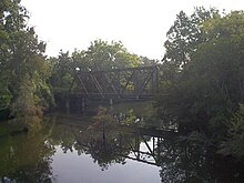
Today, it is only open to pedestrians for fishing and is part of the 223-mile (359 km) long Ouachita National Recreation Trail.
Mr. Cowley graduated from the University of Missouri with a BS degree in Forestry and began working for the US Forest Service in 1954.
As a Recreation Staff Specialist with the US Forest Service in Hot Springs, he assisted in the first phases of construction of the Ouachita Trail.
Mr. Cowley died on Mar 4, 2010, just one year prior to the 40th anniversary of the completion of the initial sections and opening of the trail.
The nine original shelters along the eastern portion of the trail were built by the United States Forest Service (USFS) in the 1980s and 1990s.