Aerial photographic and satellite image interpretation
The most basic are the elements of image interpretation: location, size, shape, shadow, tone/color, texture, pattern, height/depth and site/situation/association.
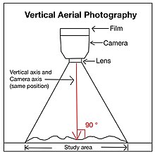
[4]Oblique aerial photographs are captured when the cameras are set at specific angles to the land.
[2] It allows the vision to pass through a relatively high proportion of the plant cover and leaves of trees.
[3] The horizon, the dividing border between planet and atmosphere from a viewing angle,[6] is unobservable in a low oblique aerial photograph.
[5] The length between two points is unable to be calculated and is not accurate because a low oblique image does not have a scale.
[5] Low oblique photographs can be used as a reference before site investigation because they give updated details of local places.
[5] High oblique aerial photographs are widely used in assisting field investigation because the line of sight shown is more similar to humans.
[5] Topographic maps are precise, in-depth descriptions of the terrain characteristics found in the areas or regions.
[7] Black and white aerial photography is capable of producing good-quality images under poor weather conditions, such as foggy and misty air.
[5] The degradation of trees driven by the insects can also be identified using color aerial photos.
[5] It can assist in locating storage of materials in the natural environment, such as trees, wild animals and oil.
[2] This phenomenon is due to the fact that plants reflect more infrared radiation (IR) than man-made objects.
[2] High-altitude aerial photographs are taken when the plane is flying in the altitude range of 10,000 to 25,000 feet.
[2] The advantage of high-altitude aerial photography is that it can record the information of a larger area by taking one photograph only.
[9] An aerial photograph marks different data and information about the covered area and the airplane's position and condition.
[2] The purpose of overlapping the aerial photography is to generate the 3D topography or relief when using a stereoscope for interpretation.
[2]The preferred orientation of an aerial photograph is closely related to the position of the Sun and the shadow element.
[4] A datum plane, which refers to the average sea level, is essential in the displacement phenomenon.
[4] For a location which has an elevation higher than that of the datum plane, the original position will move away from the central point of the image.
[4] For a location which has an elevation lower than that of the datum plane, the original position will move closer to the central point of the image.
[4] Distortion refers to any change in an object's or region's location on an aerial photo that modifies its original features and shapes.
[4] This is a process used to modify the exposed photo film to generate an aerial photograph.