Photogrammetry
Photogrammetry is the science and technology of obtaining reliable information about physical objects and the environment through the process of recording, measuring and interpreting photographic images and patterns of electromagnetic radiant imagery and other phenomena.
[1] While the invention of the method is attributed to Aimé Laussedat,[2] the term "photogrammetry" was coined by the German architect Albrecht Meydenbauer [de],[3] which appeared in his 1867 article "Die Photometrographie.
Another is the extraction of accurate color ranges and values representing such quantities as albedo, specular reflection, metallicity, or ambient occlusion from photographs of materials for the purposes of physically based rendering.
A special case, called stereophotogrammetry, involves estimating the three-dimensional coordinates of points on an object employing measurements made in two or more photographic images taken from different positions (see stereoscopy).
Stereophotogrammetry is emerging as a robust non-contacting measurement technique to determine dynamic characteristics and mode shapes of non-rotating[8][9] and rotating structures.
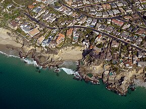
Photogrammetry is used in fields such as topographic mapping, architecture, filmmaking, engineering, manufacturing, quality control, police investigation, cultural heritage, and geology.
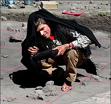
Archaeologists use it to quickly produce plans of large or complex sites, and meteorologists use it to determine the wind speed of tornadoes when objective weather data cannot be obtained.
Photogrammetry was used extensively to create photorealistic environmental assets for video games including The Vanishing of Ethan Carter as well as EA DICE's Star Wars Battlefront.
When litigation for a collision occurs and engineers need to determine the exact deformation present in the vehicle, it is common for several years to have passed and the only evidence that remains is crash scene photographs taken by the police.
Rectification of imagery is generally achieved by "fitting the projected images of each photograph to a set of four control points whose positions have been derived from an existing map or from ground measurements.
Demonstrating the link between orthophotomapping and archaeology,[20] historic airphotos photos were used to aid in developing a reconstruction of the Ventura mission that guided excavations of the structure's walls.
Suggested platforms for capturing these photographs has included: War Balloons from World War I;[21] rubber meteorological balloons;[22] kites;[22][23] wooden platforms, metal frameworks, constructed over an excavation exposure;[22] ladders both alone and held together with poles or planks; three legged ladders; single and multi-section poles;[24][25] bipods;[26][27][28][29] tripods;[30] tetrapods,[31][32] and aerial bucket trucks ("cherry pickers").
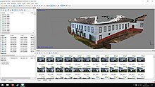
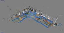
High-resolution 3D point clouds derived from UAV or ground-based photogrammetry can be used to automatically or semi-automatically extract rock mass properties such as discontinuity orientations, persistence, and spacing.