Plate Boundary Observatory
[1] EarthScope (and PBO) was a 15-year project (2003-2018) funded by the National Science Foundation (NSF) in conjunction with NASA.
PBO precisely measured Earth deformation resulting from the constant motion of the Pacific and North American tectonic plates in the western United States.
These Earth movements can be very small and incremental and not felt by people, or they can be very large and sudden, such as those that occur during earthquakes and volcanic eruptions.
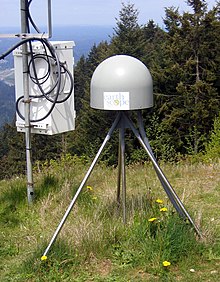
PBO measured Earth deformation through a network of instrumentation including: high precision Global Positioning System (GPS) and Global Navigation Satellite System (GNSS) receivers, strainmeters, seismometers, tiltmeters, and other geodetic instruments.
The PBO GPS network included 1100 stations extending from the Aleutian Islands south to Baja and eastward across the continental United States.