Polder
A polder (Dutch pronunciation: [ˈpɔldər] ⓘ) is a low-lying tract of land that forms an artificial hydrological entity, enclosed by embankments known as dikes.
Some animals dig tunnels in the barrier, allowing water to infiltrate the structure; the muskrat is known for this activity and hunted in certain European countries because of it.
[4][better source needed] About half the total surface area of polders in northwest Europe is in the Netherlands.
Water boards hold separate elections, levy taxes, and function independently from other government bodies.
The 1953 flood disaster prompted a new approach to the design of dikes and other water-retaining structures, based on an acceptable probability of overflowing.
The particular established policy guides the Dutch government to improve flood defences as new data on threat levels become available.
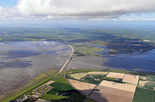
Major Dutch polders and the years they were laid dry include Beemster (1609–1612), Schermer (1633–1635), and Haarlemmermeerpolder (1852).
[11] The Lijia (里甲) self-monitoring system of 110 households under a lizhang (里长) headman was used for the purposes of service administration and tax collection in the polder, with a liangzhang (粮长, grain chief) responsible for maintaining the water system and a tangzhang (塘长, dike chief) for polder maintenance.
The German Deichgraf system was similar to the Dutch and is widely known from Theodor Storm's novella The Rider on the White Horse.
In southern Germany, the term polder is used for retention basins recreated by opening dikes during river floodplain restoration, a meaning somewhat opposite to that in coastal context.