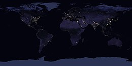
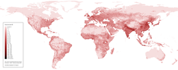
Population geography
This branch of geography integrates demographic data with spatial analysis to understand patterns such as population density, urbanization, and migration trends.
[1] Contributions to population geography are cross-disciplinary because geographical epistemologies related to environment, place and space have been developed at various times.
Pioneered by Glenn Trewartha, Wilbur Zelinsky, William A. V. Clark, and others in the United States, as well as Jacqueline Beaujeu-Garnier and Pierre George in France, it focused on the systematic study of the distribution of population as a whole and the spatial variation in population characteristics such as fertility and mortality.
[1] Population geography defined itself as the systematic study of: Accordingly, it categorized populations as groups synonymous with political jurisdictions representing gender, religion, age, disability, generation, sexuality, and race, variables which go beyond the vital statistics of births, deaths, and marriages.
[1] Given the rapidly growing global population as well as the baby boom in affluent countries such as the United States, these geographers studied the relation between demographic growth, displacement, and access to resources at an international scale.