Queen Elizabeth Way
In 1997, the provincial government turned over the responsibility for the section of the QEW between Highway 427 and the Humber River to the City of Toronto, which redesignated this segment as a westward extension of the Gardiner Expressway.
The monument was removed in 1972 in order to accommodate widening of the original QEW, and relocated in August 1975 to the nearby Sir Casimir Gzowski Park along Lake Ontario, on the east side of the Humber River.
[9] The QEW is a 139 km (86 mi) route that travels from the Peace Bridge – which connects Fort Erie with Buffalo, New York – to Toronto, the economic hub of the province.
It runs as a freeway circling the western lakehead of Lake Ontario, cutting through Niagara Falls, St. Catharines, Hamilton, Burlington, Oakville, and Mississauga en route.
After passing the Ontario Street (Regional Road 42) interchange, the freeway crosses Martindale Pond, which forms the mouth of Twelve Mile Creek.
[11] Throughout Lincoln, the QEW travels along the Lake Ontario shoreline through the Niagara Fruit Belt; numerous wineries line the south side of the freeway.
After crossing Etobicoke Creek, which forms the boundary between Peel Region and Toronto, the route passes through a sprawling four-level interchange with Highway 427, as the freeway continues eastward as the municipal Gardiner Expressway.
[10] The QEW formerly continued beyond the Highway 427 interchange to the Old Toronto city limits at the Humber River, although this section between was downloaded from provincial to municipal authorities on April 1, 1997 and became a westward extension of the Gardiner Expressway.
Provincial control of the freeway ends shortly after an onramp from Highway 427; municipal ownership is evident from the use of different high-mast illumination poles that are shaded to reduce light pollution at the underpasses with Wickman Road and a railway line.
East of Grand Avenue, the municipality's shaded high-mast lighting has been erected as the freeway crosses Parklawn Avenue and a CN rail line followed by offramps to Lake Shore Boulevard, then it curves as it passes the residential condominium towers of The Queensway – Humber Bay neighbourhood along the waterfront, the Mr. Christie cookie factory (which later became a part of Mondelēz International) and the Ontario Food Terminal on the north side, and then a tunnel leading to the Humber Loop streecar right-of-way.
[14] As the freeway crosses the west bank of the Humber River this marks the QEW's old eastern terminus and the beginning of the Metro Toronto-constructed portion of the Gardiner.
[21] Though many minor improvements in alignment were made, the original highway was without modern bridges for the crossings of the Credit River and Bronte, Etobicoke, and Mimico Creeks.
Over a ten-week period in the late spring and early summer of 1940, 58 km (36 mi) were paved, completing the four-lane highway between Hamilton and Niagara Falls.
It soon came time to name the new highway, and an upcoming visit by King George VI and Queen Elizabeth proved to be the focal point for a dedication ceremony.
On June 7, 1939, the two royal family members drove along both the newly connected Toronto-Hamilton and Hamilton-Niagara Falls highways and passed through a light beam near the Henley Bridge in St.
[40] Over a ten-week period in the late spring and early summer of 1940, 58 km (36 mi) were paved, completing the four-lane highway between Hamilton and Niagara Falls.
This, combined with the ever-increasing number of automobiles, traffic jams, accidents, and deteriorating pavement, led the Department of Highways to state it had begun "salvaging" the QEW in its 1953 annual report.
[52] The Freeman Diversion opened to traffic in August 1958,[53] with the old alignment becoming an eastward extension of Plains Road (still directly accessible via a split west of Guelph Line).
[42][45] The four-level junction with Highway 27 was built over 48.5 ha (120 acres) and required the construction of 19 bridges and the equivalent of 42 km (26 mi) of two-lane roadway, as well as the temporary diversion of QEW traffic to an overpass that would eventually be used for The Queensway.
[78] To resolve this, the renamed Ministry of Transportation began planning for the missing link of Highway 403 between Burlington and Mississauga that would run parallel to the QEW;[79] this right-of-way would be sold to the 407 ETR consortium in 1995 and built as part of that route.
[80] Work began in August 1991 to reconfigure the directional-T interchange to modern standards, which included realigning the QEW carriageways as mainline traffic, and adding a fourth leg for the future Burlington-Mississauga link.
Worn-out bilingual provincial signage have received unilingual replacements, while billboards which the province had long prohibited have been erected in proximity of the now-municipal freeway.
[15] The Shook's Hill rotary interchange (originally opened in 1960) with Erin Mills Parkway and Southdown Road, was completely reconstructed to a conventional parclo A4 from May 1999 to 2001.
The interchange with Guelph Line (originally a full cloverleaf when built, with the northern half modified to a diamond in the mid-1960s[93][94]) was reconfigured to modern Parlo A4 that exclusively served QEW traffic after the ramps to Plains Road were removed, which was completed in 2006.
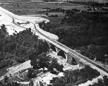
[98] This segment whose original design dated back to 1939, saw several interchanges improved and numerous structures replaced, although the widened Henley Bridge kept its classic architecture while existing service roads and local properties beside the freeway were largely retained.
[101] As part of the future widening of the QEW, the existing cast-in-place concrete bridges for the North Shore Boulevard underpass were joined by two precast box girder structures on either side in 2021.
From November 2016 to 2020, the 1970s-era bridges carrying QEW traffic across Ford Drive and the eastbound ramp to Highway 403 were demolished and replaced by new wider structures which can accommodate future HOV lanes and high-mast lighting.
In November 2019 the Ford government announced that the historic bridge would be demolished and replaced,[107] but changed course due to public opposition on December 18 by restricting project bids to those that would rehabilitate the structure.
[112][113] On December 7, 2015, Ontario's Transportation Ministry announced it was working on a plan to create permanent high-occupancy toll lanes (HOT) on a 16.5-kilometre (10.3 mi) stretch, in both ways, between Trafalgar Road in Oakville and Guelph Line in Burlington starting on September 15, 2016.
[1] As the principal travel route between Toronto and Buffalo, whenever sports teams from the two cities face each other (particularly the Sabres and Maple Leafs in the National Hockey League) the game is called The Battle of the QEW.