Black Creek Drive
The Province of Ontario and Metropolitan Toronto sought to build the Highway 400 south extension to reach the Gardiner Expressway.
As a compromise, the province constructed the route as a limited controlled-access expressway with at-grade intersections and transferred it to the municipality upon completion.
[3][4] At its south end, Black Creek Drive begins at an intersection with Weston Road and Humber Boulevard, in the Mount Dennis neighbourhood of Toronto.
The four-lane road passes beneath railway tracks that carry the Kitchener GO Line and Union Pearson Express rail corridors.
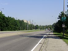
[6] Between Trethewey Drive and Lawrence Avenue West, the road passes between residential subdivisions within the Black Creek ravine.
[1][5] After Maple Leaf Drive overpass, the route becomes the provincial Highway 400 and thereafter falls under the control of the Ministry of Transportation of Ontario, including the interchange with Jane Street.
[8] Although the city classifies it as an arterial road (Google Maps also colour-codes it as an arterial unlike other expressways with at-grade crossings like Highway 7 (York Regional Road 7) between Vaughan and Richmond Hill[1]), the section north of Eglinton Avenue fits the definition of a limited controlled-access expressway since bicycles and pedestrians are banned from using the roadway or paved shoulders.
[10] The provincial government began construction of an extension of Highway 400 as far south as Jane Street in 1965,[17] which was completed and opened on October 28, 1966,[18] while the remainder of the plans were shelved following the cancellation of the Spadina Expressway in 1971.
[19] The provincial government still owned the right-of-way along the Black Creek Valley and agreed to construct it as a four-lane expressway with at-grade intersections (labelled as an arterial road for political convenience), instead of six-lane freeway with grade-separations.