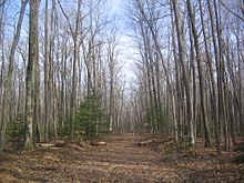
Quehanna Wild Area
Founded in the 1950s as a nuclear research center, Quehanna has a legacy of radioactive and toxic waste contamination, while also being the largest state forest wild area in Pennsylvania, with herds of elk.
Quehanna Wild Area has many sites where radioactive and toxic waste was buried, some of which have been cleaned up while others were dug up by black bears and white-tailed deer.
To fill the void left by the demise of the Susquehannocks, the Iroquois encouraged such displaced eastern tribes as the Shawnee and Lenape (or Delaware) to settle in the West Branch watershed.
[4] In the 1950s the Curtiss-Wright Corporation coined the name "Quehanna" for its nuclear reservation, which it derived from the last three syllables of "Susquehanna",[7] "in honor of the river that drained the entire region".
[11] Scull's 1770 map of the Province of Pennsylvania showed the colonists' ignorance of the land north of the West Branch Susquehanna River; Sinnemahoning Creek was missing, and the region that includes Quehanna was labeled "Buffaloe Swamp".
Some settlers would harvest timber and float it downstream once a year to make money for items they could not produce themselves, but by 1820 the first full-time lumbering operations began in the region.
For example, in 1871 a single splash dam on the Bennett Branch of Sinnemahoning Creek could release enough water to produce a wave 2 feet (0.6 m) high on the main stem for two hours.
The soil was depleted of nutrients, fires baked the ground hard, and jungles of blueberries, blackberries, and mountain laurel covered the clearcut land, which became known as the "Pennsylvania Desert".
[35][36] In a December 8, 1953 speech to the United Nations, President Dwight D. Eisenhower announced a new Atoms for Peace policy, and Congress enacted his program into law the following year.
[37] Under the new program, the airplane manufacturer Curtiss-Wright Corporation sought a large isolated area in central Pennsylvania "for the development of nuclear-powered jet engines and to conduct research in nucleonics, metallurgy, ultrasonics, electronics, chemicals and plastics".
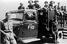
[38][39] Curtiss-Wright worked closely with the state, and in June 1955, Governor George M. Leader signed legislation that authorized the construction of a research facility at Quehanna.
Both of these were on the land which Curtiss-Wright had purchased, which was a regular octagon surrounded with a 24-mile (39 km) fence built by forest rangers, supervised from three guard houses on Quehanna Highway and Wykoff Run Road.
At this site, a Curtiss-Wright division manufactured Curon foam for furniture and household products and used beryllium oxide to make high-temperature ceramics for application in the nuclear industry.
[40] Curtiss-Wright spent $30 million on the project, and developed a community for its scientific and technical staff at the village of Pine Glen, southeast of Karthaus in Centre County.
[40] On August 20, 1960, Curtiss-Wright announced that it was donating the reactor facility to Penn State and selling its Curon foam division; the remaining 235 employees lost their jobs.
[50] Although Martin Marietta completed its AEC contract and its lease expired on December 21, 1966, it had to stay at the reactor site "until radiation contamination was brought to acceptable levels".
PermaGrain also let Neutron Products, Inc., a Maryland company, do cobalt-60 work in its hot cells, which required an amendment of their license from the Nuclear Regulatory Commission (NRC, the successor to the AEC).
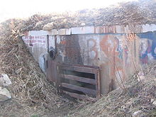
[8][38][52] In 1993, strontium-90 contamination in the reactor facility led the NRC to require PermaGrain to begin decontamination work, and the Pennsylvania DEP commissioned a "site characterization study".
A former employee told how a night watchman walked through a spill in the reactor complex without knowing it; the man's car and the carpets in his house had to be destroyed as a result of the contamination.
At the wire-burning site 150 short tons (140 t) of contaminated soil were removed from 3 acres (1.2 ha), with clean earth and grass seed placed on top of the area.
Parts of the trail have been moved, away from damage caused by the 1985 tornado, to avoid pipelines, to circumvent the Piper Boot Camp, and to pass closer to streams.
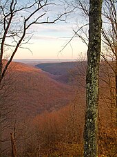
[2] The area falls into portions of two distinct geological physiographic provinces, with all but the northernmost part in the Pittsburgh Low Plateau, known for its coal and mineral deposits, and characterized by steep-cut stream beds.
The land on which Quehanna Wild Area sits was part of the coastline of a shallow sea that covered a great portion of what is now North America in the Pennsylvanian subperiod.
Below this is the Pennsylvanian Pottsville Formation, a gray conglomerate that may contain sandstone, siltstone, and shale, as well as anthracite coal, and which forms much of the Quehanna plateau.
[41][92] It traveled over 69 miles (111 km) of mainly dense forest and wilderness in central Pennsylvania, and damaged or destroyed buildings early in its life, including a CCC-built lodge at Parker Dam State Park.
By the early 21st century, many of the trees in Quehanna were 80 to 100 years old, and the maturation of the forests led to the disappearance of species like bobwhite quail, ring-necked pheasant, and snowshoe hare; white-tailed deer, ruffed grouse, black squirrel, and cottontail rabbit all became less common.
Common animals found in Quehanna include chipmunks, porcupine, and beaver, omnivores such as the black bear and raccoon, and predators like bobcat, red fox, and coyote (which has been in Pennsylvania since the 1930s).
The shrub and scrubland areas left by the 1985 tornado and cleared for elk to feed in are home to indigo bunting and prairie warbler, while ponds and wetlands attract waterfowl such as hooded merganser and wood duck, and wading birds like great blue heron.
[110] As of 2010, the Pennsylvania Game Commission allowed hunting of the following species found in Quehanna Wild Area: American crow, beaver, black bear, black squirrel, bobcat, bobwhite quail, cottontail rabbit, coyote, elk, house sparrow, raccoon, red fox, ring-necked pheasant, ruffed grouse, white-tailed deer, wild turkey, and woodcock.
The club has also provided food plots for deer and elk, fed game animals in winter, planted and pruned fruit trees, stocked fish, and treated streams for acid rain.