Trexler Nature Preserve
In 1901 local industrialist General Harry Clay Trexler, began purchasing much of the surrounding farmland in order to form a "deer reservation".
[9] An early environmentalist, Trexler believed that much of the large wild game in the United States had been hunted to the brink of extinction and that efforts were needed to protect those that remained.
[8] A contemporary source described the project as follows:[8] In 1901, General Harry C. Trexler embarked in a great agricultural enterprise which has attracted marked attention, not only in Lehigh County but throughout the entire State of Pennsylvania.
He immediately began to turn up the soil of the hilly, unprofitable land and sow seeds in order to secure permanent pasture, and when these made their appearance he set apart about 1,000 acres, enclosed with an 8-foot wire fence, and placed there seventy deer and several buffaloes and elk.
The overwhelming response was that the land should be brought back to its natural state (much harmed after years of inartful range management) and that passive recreational facilities (such as hiking trails) should be constructed.
[13] In response to this input, Lehigh County commissioned and built a new trail system and, as of 2013, continues efforts to reclaim the land from damage caused by inartful range management.
The Martinsburg Formation developed during the Ordovician period (490 to 443 million years ago), and is characterized by dark grey shale and thin beds of siltstone and sandstone, with depths up to 12,000 feet.
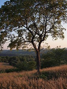
Mill Creek also provides a perennial source of water which helps to maintain the thicket of deciduous trees, which are principally oak and maple and grow on the preserve's north-western boundary.
Hegel's Run is a perennial minor tributary of Jordan Creek, originating within skunk cabbage wetlands in the interior of the preserve.
Flowing north to south, Hegel's Run continues out of the wetlands and parallel to the Fireman's trail where, along its course, it is fed by two smaller unnamed tributaries originating from springs on the sloping Mill Hill which are blanketed by a heavy canopy of autumn-olive and by a minor tributary originating to the northeast in the grassy Schantz valley.
Hegel's Run flows further south where, after being crossed by the firemen's trail forms a confluence with Jordan Creek immediately upstream of Schlicher's Covered Bridge.
[23] After passing under Schlicher's Covered Bridge and a pedestrian footbridge, the Jordan Creek makes a hairpin curve, ultimately turning to flow straight south.
Thicket Run drains two small ponds in the South Range before flowing to the Jordan under a makeshift metal bridge which carries the Trexler Border Trail.
It is bounded on the north by the Jordan Creek and Hegel's Run and on the south by Old Packhouse Road—a portion of the southern end is occupied by the Lehigh County composting facility.
The extreme eastern boundary which borders Lehigh Carbon County Community College is marked by a deciduous tree-line of walnut, oak, and maple receding into grasslands interspersed with autumn-olive.
[25] Atop a grassland ridge line in the Eastern Central Range is the post-modern Prairie School styled environmental education center.
[27] The center is on one of the highest parts of the preserve and features straight lines, a low profile, and muted colors which merge the building into dramatically rolling grasslands.
It also has a rooftop observation area, a community room for environmental education programs and meetings, and restroom facilities for park visitors.
The Trexler nature trail, which follows Jordan Creek from the ford has views of the river, as well as mixed deciduous and conifer forest and exposed shale formations which are often covered in damp mosses.
[25] Much of the preserve consists of rolling expanses of grassland, is characterized by landscape that is unnatural to eastern Pennsylvania and is dominated by non-native plant species.
This is a consequence of the early history of the preserve as poorly managed reservation for large ruminant animals and as an experimental apple orchard.
[25] Natural grasslands are typically limited to semi-arid areas of the world which have long periods of low humidity, intermittent rainfall, and large herds of wild ruminants.
[25] With no natural competition, autumn-olive, stilt grass, garlic mustard, ailanthus, Japanese barberry, and oriental bittersweet grew without control.
In these areas large stands of oak, maple, walnut, hemlock, and pine still exist along with native wildflowers, mosses, and where moist, ferns.
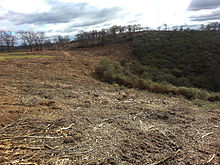
[25] By far, the worst disruption to the park has been caused by autumn-olive which easily colonized the grasslands and deciduous under-story of all parts of the preserve—and particularly the steep hillsides of the Northern Range.
Despite the difficulties, in October and November 2015, the Trexler Nature Preserve has stepped up efforts to mechanically clear hundreds of acres of autumn-olive from the northern range.
This effort requires a pair bulldozers equipped with a mechanical grinder that slowly make their way up and down the steep hills grinding and pulverizing the thorny, bush like autumn-olive into rough mulch.
[32] The preserve has also started a project to reintroduce American chestnut - a native tree that was nearly destroyed by blight at the end of the nineteenth century.
[5] In 2006, as a settlement to litigation brought by the Trexler Trust, Lehigh County agreed to reopen the entire preserve for public use.
[4] Starting in the late 2000s, Lehigh County, with the assistance of the Trexler Trust undertook to build a new system of trails in the interior of the preserve.