River Walbrook
[7] The western side was more populous and prosperous, it had the cathedral, the royal palace (which later moved to Westminster) and its large market, Westcheap, was focussed on land-based trade.
The east was poorer and more sparsely settled; its smaller market, Eastcheap, was sited near the river to allow it to specialise in seaborne trade.
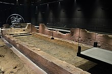
In 1838 construction workers building a new sewer under Blomfield Street, on the course of the Walbrook, discovered very large numbers of human skulls,[11] though very few other bones were present.
His History of the Kings of Britain explained their origin as resulting from a massacre occurring during a Roman civil war, the Carausian Revolt of AD 286–296.
In Geoffrey's account, a Roman legion under Livius Gallus, besieged in London, agrees to surrender to the forces of Julius Asclepiodotus on condition they are given safe passage out of Britain.
Geoffrey wrote that the river was afterwards named after Livius Gallus, the leader of the beheaded Romans, as Nantgallum in Welsh (the language of the native Britons), or in the Saxon English as Galobroc, from which Walbrook was derived.
Archaeological excavations across this area in the late 20th and early 21st centuries (two examples are Finsbury Circus[14] and Liverpool Street [15]) revealed a Roman burial ground which included graves scoured by the River Walbrook, and it was suggested that skulls might come from this.
Other factors should also be considered here: the 'heads' or 'skulls' which have been recovered were actually crania (ie only the main/top part of the skulls - the accompanying jaw bones, which would have provided vital evidence for beheadings, execution or indeed massacre, were missing); human skulls are profoundly identifiable as being human and are more likely to have been spotted and collected during construction work - every single controlled archaeological excavation in this area has also uncovered other human bones, creating less of a bias towards 'skulls'; the crania recovered recently at Liverpool Street had a wide date range and therefore could not have amassed as the result of a single event (the 2nd-century bias noted above probably simply reflects the size of Roman London's population).
The river appears to have had a main eastern branch which ran from Hoxton, in the parish of Shoreditch, and one or more others flowing from Finsbury to the west.
Just to the north of wall, the main branch (Deepditch) formed the boundary of the city wards of Coleman Street to the west, and Bishopsgate Without to the east.
[20] The brook flowed southward through the centre of the walled city, bringing a supply of fresh water whilst carrying waste away to the River Thames, at Dowgate; it effectively divided the settlement in two.
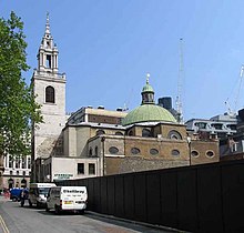
When the church of St Margaret Lothbury was rebuilt in 1440, the Lord Mayor Robert Large paid for the lower Walbrook to be covered over.
John Stow, the historian of London, wrote about the Walbrook in 1598, saying that the watercourse, having several bridges, was afterwards vaulted over with brick and paved level with the streets and lanes where it passed and that houses had been built so that the stream was hidden as it is now.
This included the culverted Walbrook, which by 1860 had been linked into a network of 82 miles (132 km) of new sewerage lines, channelled to the Northern Low Level Sewer at a point near the Bank of England.